Two Lakes and the Mountains of the Moon
Ptolemy’s map of Africa [see the 1554 map of the continent by Sebastian Münster] shows the Nile flowing from two parallel lakes fed by waters from mountains (the Mountains of the Moon, though not named there). He cited as his sources the tales of the Greek merchant Diogenes and other travelers who claimed to have journeyed inland from the coast of East Africa and looked upon two great lakes and snowy mountains. Unnamed by Ptolemy, these lakes on later maps acquired the names of Zaire lacus (Lake Zaire) and Zaflan lacus (Lake Zaflan). Sometimes they were aligned side by side; often, one was placed forward like a footstep. This tradition in Africa maps continued well into the 1700s. Guillaume de L’Isle (1675-1726), often called the father of modern geography because of his scientific approach to the subject, was the first cartographer to discard the lakes. On his map “L’Afrique dressée sur les observations de Ms. de l’Academie Royale des Sciences . . .,” first issued in 1700, he gave the correct source for the Blue Nile as Lake Tsana (Tana) in Abyssinia (Ethiopia), no doubt based on the 17th-century accounts of Portuguese missionaries, including Pedro Páez and Jerónimo Lobo.
The first known “expedition” up the Nile was undertaken by two centurions sent by the Roman emperor Nero in the first century A.D. They failed, however, to get past the Sudd—the great swamp of thickets and aquatic vegetation of the White Nile that lies between the latitudes 5° and 10° north in southern Sudan. Not until the 1860s explorations of Burton, Speke, Baker, and Grant—further confirmed by Stanley in the 1870s—was the puzzle of the lakes resolved. The sources of the White Nile lie in the feeder streams and rivers of Lake Victoria; its waters issue out at Ripon Falls (submerged now by the Owen Falls Dam) and then course through and out Lake Albert, joining the Blue Nile at Khartoum. Conceivably, Lake Victoria and Lake Albert were Ptolemy’s two lakes. The Ruwenzori mountain group, on the boundary between Uganda and the Democratic Republic of the Congo, between Lake Albert and Lake Edward, contain snow-capped peaks that reach over 16,000 feet. First identified by Stanley in the 1880s, these mountains are now usually associated with Ptolemy’s Mountains of the Moon. Scholarship has shown that Ptolemy did not originate the concept of the "Mountains of the Moon" and their role as the source of the Nile River—it was probably an inherited Arab idea—but the popularity of his Geographia [see Ptolemy] greatly accounted for the propagation of it. [For a thorough argument, see William Desborough Cooley, Claudius Ptolemy and The Nile . . . (London, 1854).]
1655
1665 map
Kircher, Athanasius, 1602-1680.
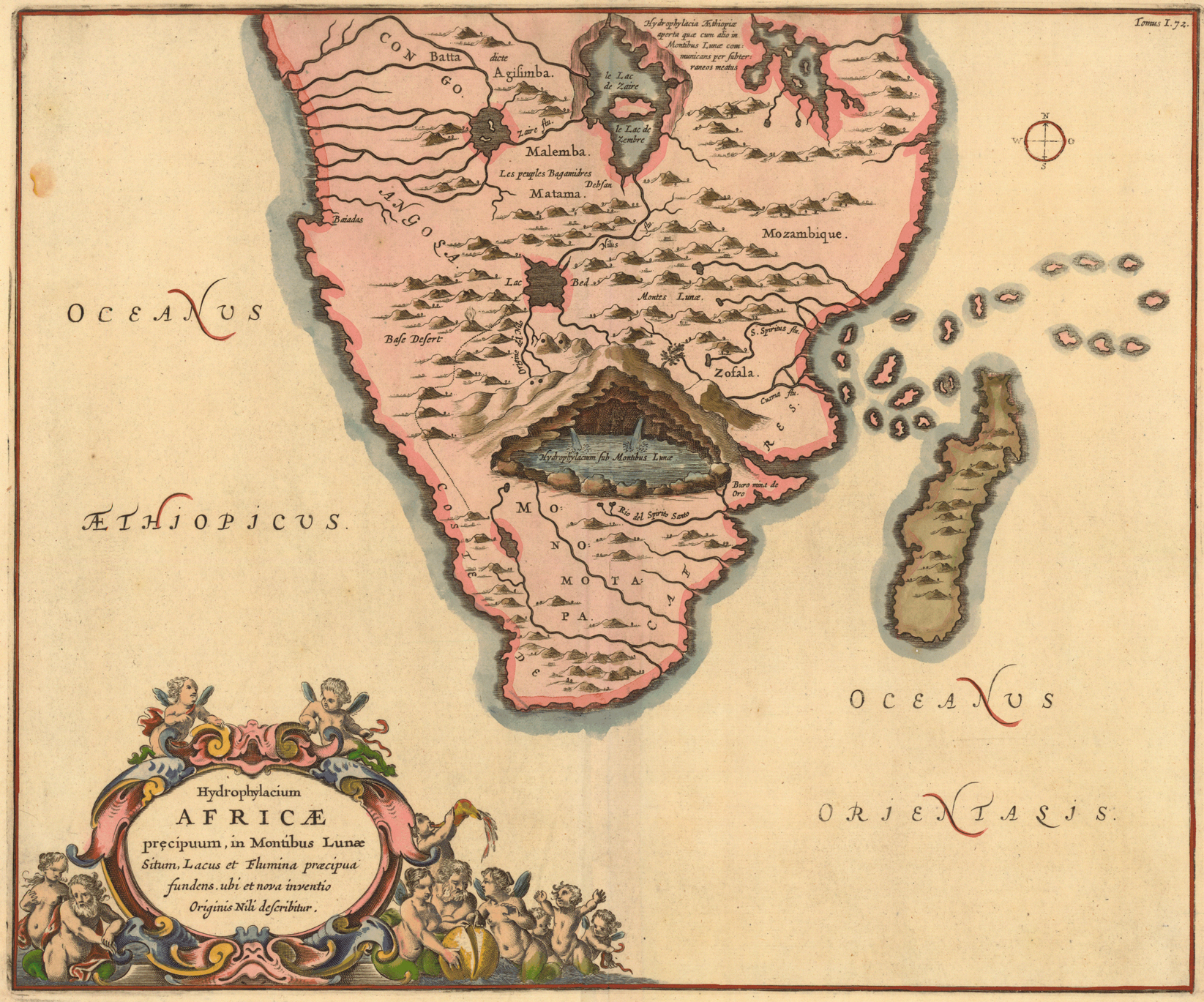
“Hydrophilacium Africæ precipuum, in Montibus Lunæ situm, lacus et flumina præcipua fundens, ubi et nova inventio originis Nili describitur.” Copperplate map, 35 x 42 cm. From Kircher’s Mundus subterraneus . . . (Amsterdam, 1665). [Historic Maps Collection]
Sometimes compared to Leonardo da Vinci for the breadth and depth of his interests, Kircher was a German Jesuit scholar who published works on such subjects as Egyptology (and hieroglyphics), geology, and music theory. He examined the blood of plague victims under a microscope, concluding the disease was caused by microorganisms; he constructed a magnetic clock; he designed a cat piano engineered to drive spikes into the tails of cats so they would yowl to specified pitches (though he is not known to have constructed it). One historian called him the “first scholar with a global reputation”; the Encyclopædia Britannica describes him as a “one-man intellectual clearinghouse for cultural and scientific information.”
Kircher’s Mundus subterraneus, dealing with geophysics, earthquakes, and volcanoes, was one of his most popular and spectacular works, full of exotic engravings and strange theories. (Fascinated with underground rumblings, Kircher had himself lowered into Vesuvius shortly after a nearby earthquake in 1638.) In it, he published an account from the journal of Pedro Páez, a contemporary Jesuit colleague, who had visited Ethiopia in the early 1600s and described seeing the “fountains of the Nile.” James Bruce, the English Nile explorer, translated Kircher’s version in his own work, Travels to Discover the Source of the Nile (1790):
On the 21st of April, in the year 1618, being here, together with the king and his army, I ascended the place, and observed every thing with great attention. I discovered first two round fountains, each about four palms in diameter, and saw, with the greatest delight, what neither Cyrus king of the Persians, nor Cambyses, nor Alexander the Great, nor the famous Julius Caesar, could ever discover. The two openings of these fountains have no issue in the plain on the top of the mountain, but flow from the root of it. The second fountain lies about a stone-cast west from the first: the inhabitants say that this whole mountain is full of water, and add, that the whole plain about the fountain is floating and unsteady, a certain mark that there is water concealed under it; for which reason, the water does not overflow at the fountain, but forces itself with great violence out at the foot of the mountain. . . . [T]he fountain seems to be a cannon-shot distant from Geesh. . . . [Vol. 3, pp. 619-20]
Another Portuguese Jesuit, Jerónimo Lobo, claimed to have passed through the area in 1629. He offered a different (and fairly accurate) description [compare with the photographs in SCATURRO]:
In this territory of Toncua is the known head and sourse of the River Nile, by the natives called Abani (i.e.) the Father of Waters. . . . The Head rises in the most pleasant Recesse of the Territory, having two Springs, called Eyes, each about the bigness of a Coach-wheel, distant twenty paces.… These two springs rise in a little field covered over with green and thick wood. . . . This plain is on the top of a high mountain, overlooking many spacious Vallies and from this hight insensibly descends. . . . At little more than three dayes journey from the Head, the River is large, deep enough for vessels to sail in. . . . [A Short Relation of the River Nile, of Its Sourse and Current . . . (London, 1669), pp. 8-11]
Kircher’s map visualizes Páez’s description of the source of the Nile, showing the river flowing out from under the Mountains of the Moon, through Ethiopian lakes that are also linked subterraneously. It is an imaginative exercise, for none of the geography is accurate.
1690
1690 map
Coronelli, Vincenzo, 1650-1718.
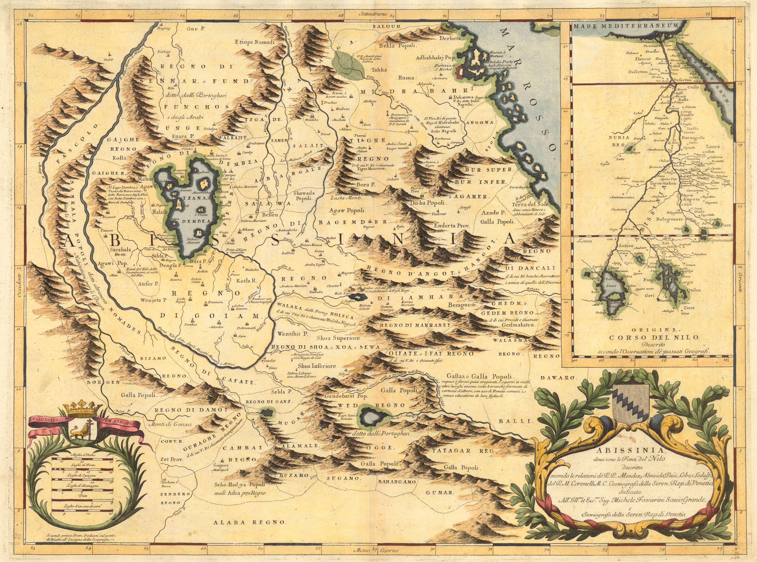
“Abissinia, doue sono le Fonti del Nilo. . . .” Copperplate map, with added color, 43 x 58 cm. From Coronelli’s Atlante Veneto . . . (Venice, 1690 or 1695). [Historic Maps Collection]
A Venetian cartographer, Coronelli created hundreds of beautifully engraved maps, but he is probably best known for his globes, which were even finer than those of Willem Janszoon Blaeu. His masterpiece was a pair of celestial and terrestial globes, 384 cm. in diameter, that he made for Louis XIV of France; the star map showed the heavens as they stood at the king’s birth. He also founded the very first geographical society, the Accademia Cosmografica degli Argonauti, in 1680.
Coronelli’s cites his sources for this Nile map, including the Portuguese Jesuits Pedro Páez and Jerónimo Lobo, and contrasts his work with an inset showing the “original” (that is, outdated) course of the Nile as presented by past geographers, who followed the Ptolemaic tradition of two source lakes. Páez and Lobo had visited Ethiopia in the early 1600s, and both gave accounts of having seen the springs that natives believed to be the river’s source, though the Jesuits failed to distinguish between the two branches of the river. Coronelli’s Nile is the Blue Nile, and his geography is fairly accurate for that branch, identifying the significance of Lake Tsana and the clockwise unfolding of the river as it descends from there. Notice that he has supplied a B to mark each of the two “fountains.” The other branch, what is now called the White Nile, is virtually ignored; it meanders in a southerly direction to its origin in vague mountains at a latitude of 9-10° north of the equator. Most of the exploration activity in the 19th century was focused on discovering the sources of the White Nile, which would lead below the equator, as ironically suggested in Coronelli’s Ptolemaic inset.
1720
1720 map
Fer, Nicolas de, 1646-1720.
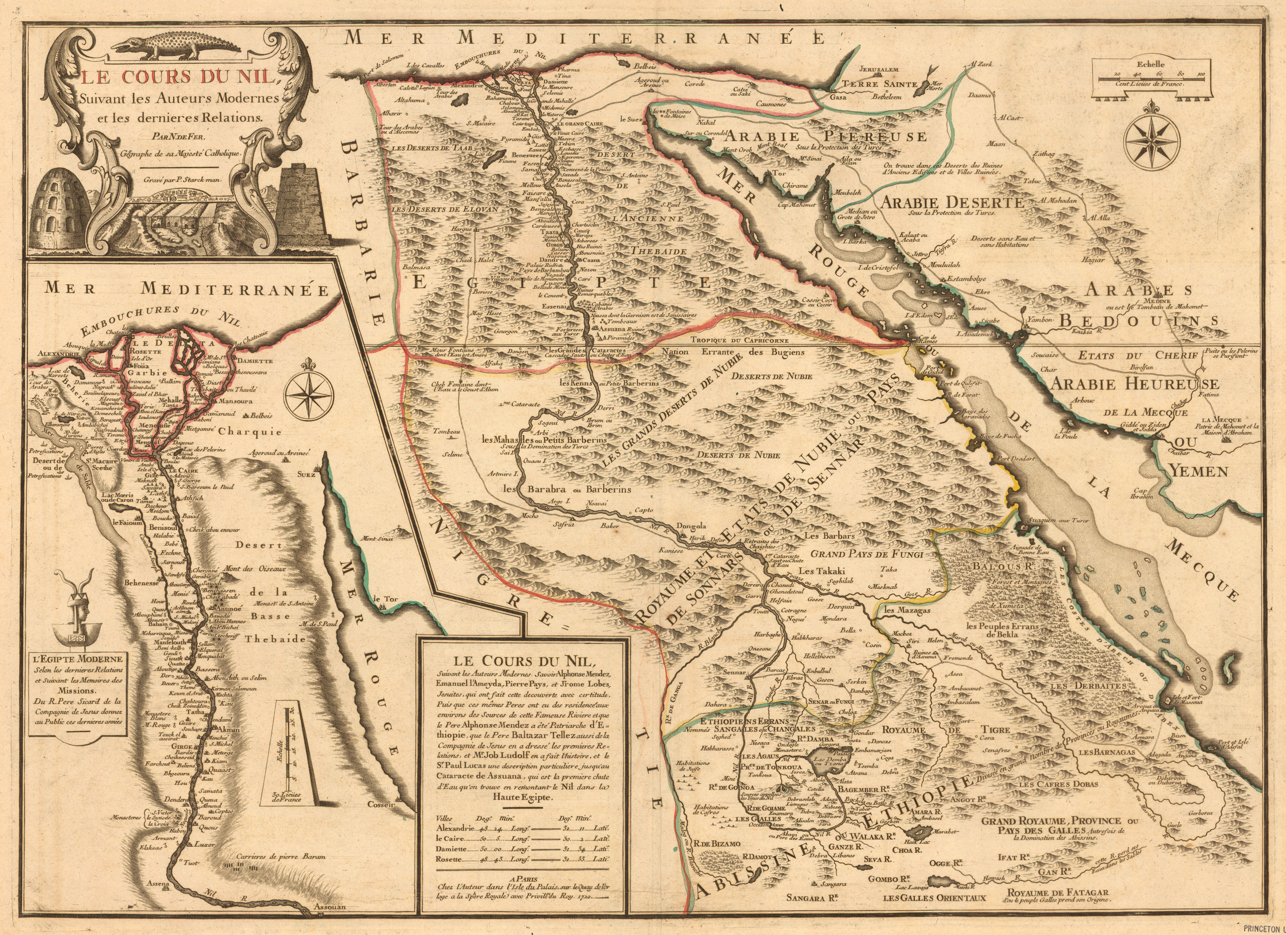
“Le cours du Nil, suivant les auteurs modernes et les dernieres relations.” Copperplate map, with added outline color, 46 x 63 cm. [Historic Maps Collection]
The son of a mapmaker, Fer turned the family business into a flourishing map publishing company in Paris and was appointed geographer to the French dauphin. This map, printed in the last year of Fer’s life, credits a number of Jesuits, including Pedro Páez and Jerónimo Lobo, for its geographic information. The sources of the Blue Nile are called les yeux du Nil (the eyes of the Nile), probably based on Lobo’s descriptions of the two springs, and they are shown residing on or in a mountain, not unlike Kircher’s representation. Again, the White Nile is barely present. Note that Khartoum, the capital of Sudan, located where the Blue and White Niles merge (and infamous in British military history), does not exist yet; it was not founded until 1821 by the Egyptian ruler Muhammed ‘Al§ Pasha as an outpost for his army.
1858
1858 map
Andriveau-Goujon, J.
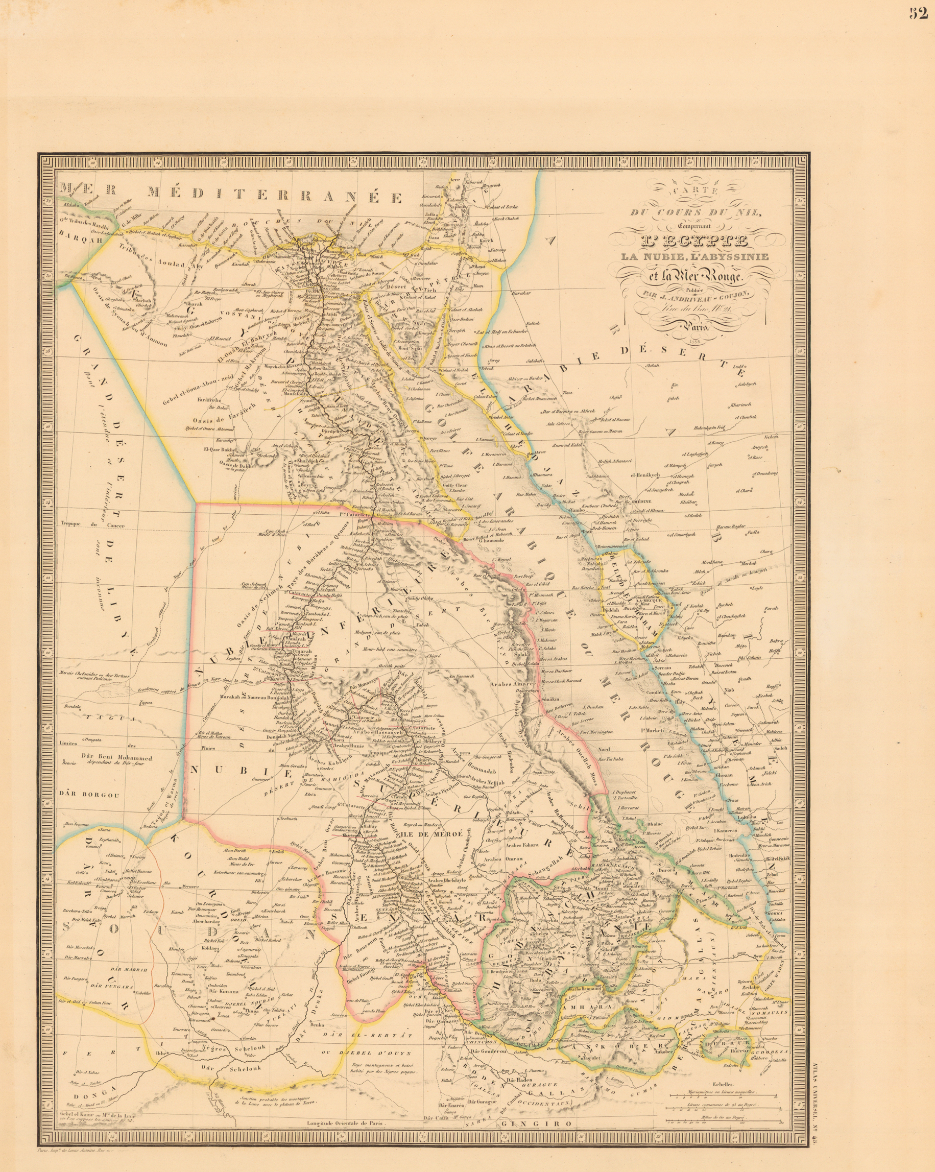
“Carte du cours du Nil, comprenant l'Egypte, la Nubie, l'Abiyssinie et la Mer Rouge. . . ." Engraved map, with added outline color, 48 x 37 cm. From Andriveau-Goujon’s Atlas classique et universel de géographie ancienne et moderne (Paris, 1858?). [Historic Maps Collection]
The focus of this factual, modern-looking map is clearly the route of the Blue Nile to its junction with the White Nile at Khartoum and the combined river’s course to the Mediterranean. Numerous place-names are shown, as are the six cataracts of the river between Asw~n and Khartoum. The Mountains of the Moon (montagnes de la lune) are present in the lower left corner, where the sources of the White Nile still elude discovery. At the time this map was published, Burton and Speke were in Tanzania pursuing just that prize. After centuries, Ptolemy is still credited as a source—his name appears next to the 20° latitude mark on the left—which underscores the remoteness and rigors of some regions.
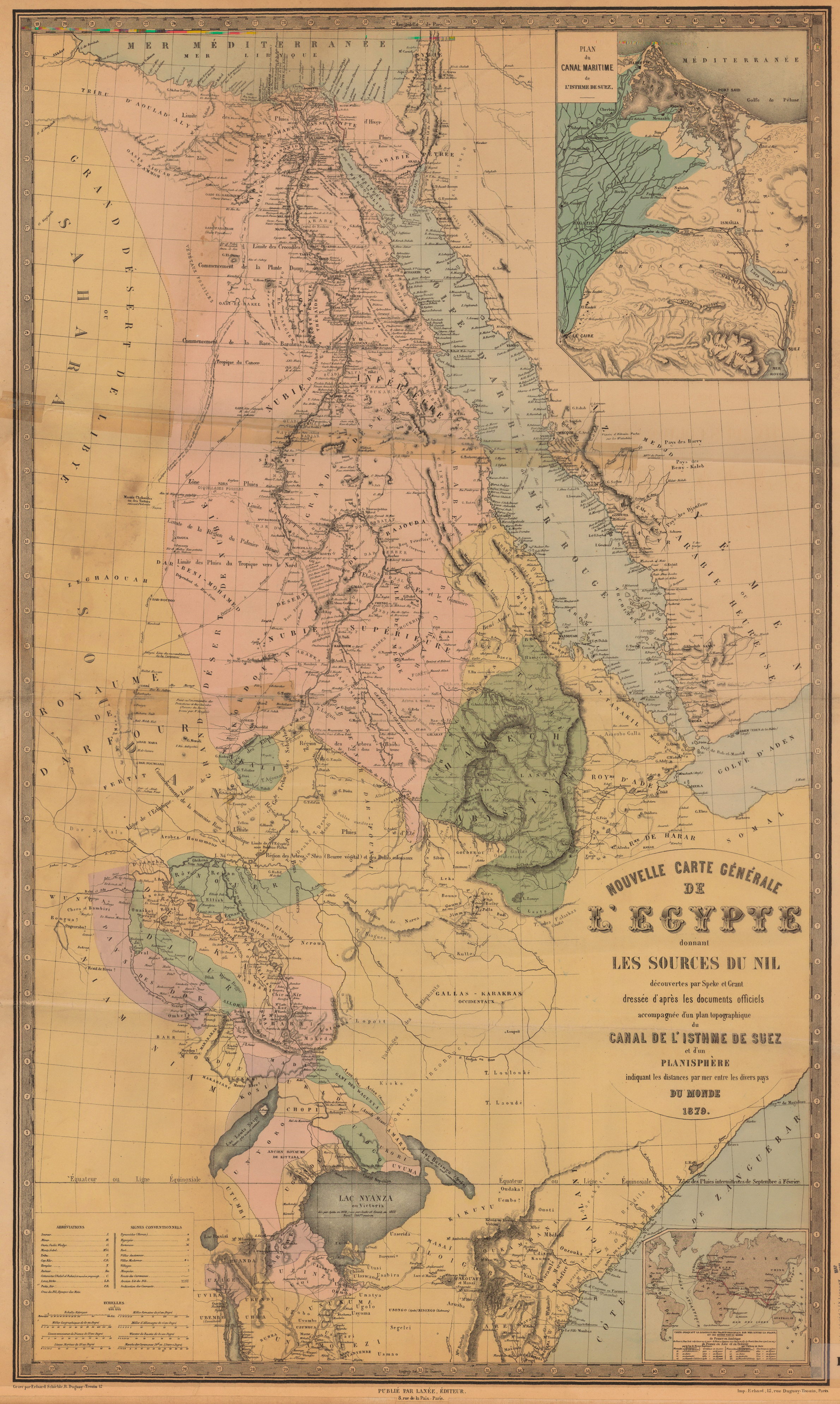
1879
1879 map
“Nouvelle carte générale de l’Egypte donnant les sources du Nil découverte par Speke et Grant. . . .” Engraved map, with added color, mounted on linen, 96 x 56 cm. [Historic Maps Collection]
The previous map’s reference to Ptolemy is still here, but the detail at the bottom (from latitude 8E north to 4Esouth) has greatly expanded, based on the discoveries of Burton, Speke, Grant, and Baker in the lake region. To confirm Speke’s assertion from his journey with Burton (1857-1859) that Lake Victoria is the source of the Nile, the Royal Geographical Society sent him and Grant on a follow-up expedition (1860-1863) to gather the geographical proof. The Suez Canal, a French project completed in 1869, is the subject of the large inset at the upper right, and the resulting advantages to France are emphasized in the lower inset: the number of days required to travel by sea to all the continents is now much reduced—in some cases, almost by half.