Libro di Benedetto Bordone: nel qual si ragiona de tutte l'isole del mondo . . . [Venice]: 1528. [Kane Collection. Rare Books Division] [Reference: Burden, North America 8.]
Born in Padua, Italy, Bordon moved to Venice around the
time Columbus sailed for the New World. There he became an illustrator,
working for noblemen, and designing woodcut illustrations and maps for
books. He is best known for printing the first atlas of island maps, commonly
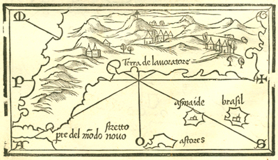
called an Isolario. Interestingly, it contains this map showing a passage,
stretto pte del modo novo, through the New World into the Pacific
Ocean. The Azores are depicted, but the fictitious islands of Brasil and
Asmaide are also represented, as well as unnamed and randomly spaced towns;
hence, the map appears more conceptual than useful. Only in broad strokes
does it feature some of the elements derived from the world map shown
at the beginning of his volume. Yet the assumption, if one may call it
that, is already evident: there must be some way to sail from one ocean
to the other, some passage through the continent. But where?