James Cook, 1728–1779
Legacy of Cook’s name: Cook Islands, Cook Strait (between the north and south islands of New Zealand), Cook Inlet (Alaska), Cook Crater (on the moon), Captain Cook (town in Hawaii), among others
[Click on the images below for high resolution versions.]

Profile portrait of Captain James Cook. Obverse of the Cook commemorative medal issued by the Royal Society in 1784. Bronze, unnumbered (1 of 500), 44 mm in diameter. Artist, Lewis Pingo (1743–1830). [Numismatics Collection]
“IAC.COOK OCEANI INVESTIGATOR ACERRIMVS” (James Cook the most intrepid investigator of the seas)
/td>In the third edition of the Encyclopædia Britannica (Edinburgh, 1797), the entry for Captain James Cook runs to thirty-nine, two-column pages. The renowned English scientist Sir Isaac Newton weakly challenges Cook’s coverage with a treatment totaling sixteen pages. Christopher Columbus merits only three; Queen Elizabeth I, Sir Francis Drake, and Sir Walter Raleigh each receive about two; Ferdinand Magellan, two paragraphs, if one includes the Magellan Strait. So great was eighteenth-century British interest in, and approbation of, the native navigator that the author of the encyclopedia article could irrefutably claim: “[I]t must be evident that the intentions of Captain Cook were in the highest degree benevolent; and if at any time the people were the sufferers, it must have been through their own fault” (vol. 5, p. 420). In the succeeding decades and centuries, a more balanced approach to the mythic status of Cook has evolved, one that grants him his humanity, still marvels at his charting skills and seamanship, and both contextualizes and judges his encounters with Pacific Ocean societies.
With hindsight, historians can mark many significant pieces that fell into place in the early years of Cook’s life. There is no diminishment of his accomplishments in noting that he was fortunate to be at the right place—historic places—at the right time with the right people. Cook was the second of eight children born to a Scottish farm laborer and his locally born wife in agricultural Yorkshire, England, and his most likely vocation was to be a farmer also. He attended a village school and showed enough promise, however, that his parents felt he might learn a trade, so they apprenticed him, at the age of sixteen (1745), to a dry goods merchant, William Sanderson, in the seaside village of Staithes.
The lure of the sea was just beyond the shop window, and the talk was fish, fishing, and foreign places. Cook managed the position for about eighteen months before an incident took place, related by his biographers, that changed the direction of his life forever. (More recent research suggests that this is an apocryphal tale.) A customer had paid for something with a shiny South Sea shilling, minted during George I’s reign for the South Sea Company, and Cook, intrigued by the thing, had replaced it with one of his own. Sanderson, however, not seeing the coin in the till, accused Cook of stealing it, which, of course, he fervently denied; his boss finally accepted his explanation. However, Cook soon asked to be relieved from his indenture because he wanted to go to sea. (The coin would be a harbinger of Cook’s own voyages to the South Sea.)
Sanderson was essential in making this happen: he arranged with his friend John Walker, a shipowner and master mariner in Whitby, to take Cook on as an apprentice seaman for three years. At that time London residents were using a million tons of coal each year, and the Whitby shipping trade supplied this need. Cook began his sea career on the Freelove, a type of ship that was designed to carry coal—flat-bottomed, capacious, and built to withstand adverse North Sea weather—called a cat. (Endeavour, Cook’s vessel for the first circumnavigation, was a similar kind of ship, also built in Whitby.) During his apprenticeship, Cook studied algebra, geometry, trigonometry, navigation, and astronomy. He worked on a number of collier ships, passed his examinations, and rose in rank from apprentice to seaman to mate. In 1755, Walker offered the now experienced twenty-six-year-old Cook his own ship but, surprisingly, was turned down: Cook wanted to enter the Royal Navy, though it meant starting at the bottom. Regretful, Walker, like Sanderson, recognized Cook’s special qualities and provided him with a glowing letter of recommendation.
On June 17, 1755, ranked as an able-bodied seaman, Cook reported for naval service at Wapping, part of the dock lands of East London, on the River Thames. During the Seven Years’ War between England and France, Cook served on several ships, including the HMS Eagle under Sir Hugh Palliser (1722–1796), who became another keen supporter of the seaman and his talents. He gave Cook opportunities for special instruction in navigation and charting; Cook was promoted to full master rank within two years. In the St. Lawrence River in Canada in the winter and early spring of 1758–1759, he undertook with others a detailed navigational survey that was critical in the successful September landing of the British troops under General James Wolfe that defeated the French at Quebec City. The resulting chart, “A New Chart of the River St. Laurence: From the Island of Anticosti to the Falls of Richelieu: With All the Islands, Rocks, Shoals, and Soundings, also Particular Directions for Navigating the River with Safety; Taken by the Order of Charles Saunders, Esqr. Vice-Admiral of the Blue, and Commander in Chief of His Majesty’s Ships in the Expedition against Quebec in 1759,”* published in London in 1760 in twelve sheets, measuring (in total) seven feet by three feet, signaled Cook’s arrival as a superb surveyor.
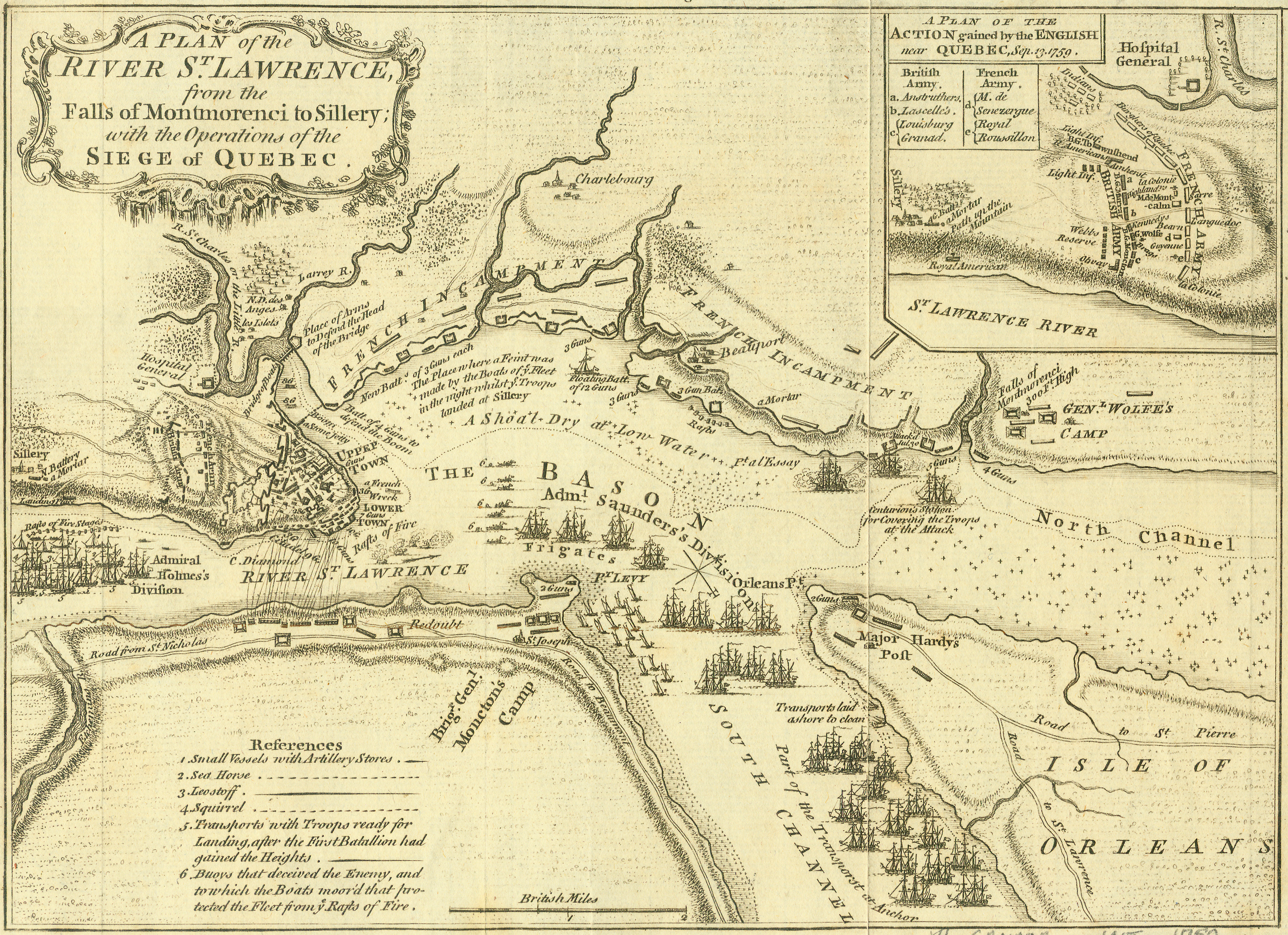
“A Plan of the River St. Lawrence, from the Falls of Montmorenci to Sillery; at the Operations of the Siege of Quebec.” Copperplate map, 17.5 × 24.4 cm. From London Magazine, November 1759. [Historic Maps Collection]
This is the first published map of the successful siege of Quebec by the British from June to September 1759, which led to the end of the French and Indian War. Shown are detailed operations of the siege and key battle sites and encampments. Cook’s surveying work on the St. Lawrence provided key information for the British fleet’s advance up the river. Anchored offshore from the Isle of Orleans with the other British warships, Cook, as master of the Pembroke, engaged in a number of dangerous activities, including laying the buoys (#6 on the map) that allowed them to tow blazing French fireships away from British targets.
While Palliser was governor general of Newfoundland, Cook spent five seasons surveying the island—which is larger than Ireland, with a six thousand–mile coastline—and the results were the first large-scale maps of the island’s coasts, still deemed astonishingly accurate in the early 1900s. This mapmaking activity included providing maps of the adjacent islands of Saint-Pierre and Miquelon, which Britain had agreed to transfer back to France in the Treaty of Paris (1763). Cook had also found time in December 1762 to marry Elizabeth Batts, a twenty-two-year-old woman from Wapping, and to become the father of two boys (1763, 1764). In 1764, Cook was given his first Royal Navy command, the schooner Grenville, in which he continued his dawn-to-dusk Newfoundland surveying and during which he incurred permanent damage and scarring to his right hand from a powder horn explosion. While back in Newfoundland in 1766, he observed a solar eclipse and transmitted his observations to the Royal Society, Britain’s prestigious scientific organization.
Completing his Newfoundland survey, Cook arrived back in London on November 10, 1767. A meeting by the Royal Society to determine its plans for observing the important, upcoming transit of Venus (June 3, 1769) took place two days later. The rest, as they say, is history—of the most compelling kind.
Endeavour, Resolution/Adventure, Resolution/Discovery—the names of Cook’s circumnavigation ships capture the themes and arc of a three-act play, reaching a dramatic climax and dénouement in Hawaii in 1779. |