Act II: The Third Voyage
Expedition (1776–1780): Two ships (Resolution and Discovery), 182 men
Charge (by the British Admiralty): To search for a Northwest Passage from the western coast of North America
Accomplishments: Discovered the Hawaiian Islands, was the first to chart Alaska’s southern coastline, and reached farther north than any previous Pacific mariner (70°44′ N)
[Click on the images below for high resolution versions.]

Fortune leaning upon a column with a spear in the crook of her arm, holding a rudder on a globe. Reverse of the Royal Society’s Cook commemorative medal. [Numismatics Collection]
“NIL INTENTATVM NOSTRI LIQVERE” (Our men have left nothing unattempted) . Under the female figure are the words “AVSPICIIS / GEORGII III” (under the auspices of George III).
The Northwest Passage—a northern navigable route linking the Atlantic and Pacific Oceans, hence a shorter path to the riches of the East Indies by avoiding the two capes (Horn and Good Hope)—had been an off-and-on obsession of the British government and merchant community for several hundred years, dating back to the multiple voyages of John Cabot (d. 1498), Sir Martin Frobisher (ca. 1535–1594), and John Davis (1550?–1605). In 1775, the government offered a prize of £20,000 for its discovery, to be shared among the crew of the successful ship.
Within months after his return from his second voyage, Cook was party, only in an advisory role, to the Admiralty’s confidential plans to send a two-ship expedition to search for such a passage from the northern Pacific. (He had been offered an attractive sinecure at the Royal Hospital at Greenwich.) But the attraction of the sea was too strong, and during a meeting on January 9, 1776, ostensibly arranged to select the officers for the new expedition, Cook suddenly stood and, after a dramatic pause, declared that he would lead the project if his companions—Sir Hugh Palliser, Philip Stephens, and John Montagu, earl of Sandwich, the three most important men of the Royal Navy (comptroller, secretary, and first lord of the Admiralty)—agreed. Cheers rang out. How could they reject the offer of such a worthy volunteer? (They probably had anticipated it.)
During the interminable delays in departing, Cook worked tirelessly on his second-voyage narrative (fortunately, Hawkesworth had died) and sat for a number of portraits (the one by Nathaniel Dance is considered the best likeness). Since arriving back, the navigator had been promoted to post-captain, a commission handed to him personally by King George III; was made a fellow of the Royal Society and contributed an article on the health of seamen to its journal, Philosophical Transactions, for which he would win the prize medal for best contribution of the year; and enjoyed the London social scene with such figures as Sir John Pringle, president of the Royal Society, and James Boswell. On the home front, Cook added another son, Hugh (named after friend and patron Palliser), in May; the other surviving children, James and Nathaniel (infant George had been born and died in 1772), were following the career of their father by entering the Portsmouth Naval Academy.
Book:
Cook, James. A Voyage to the Pacific Ocean. Undertaken, by the Command of His Majesty, for Making Discoveries in the Northern Hemisphere, to Determine the Position and Extent of the West Side of North America; Its Distance from Asia; and the Practicability of a Northern Passage to Europe. Performed under the Direction of Captains Cook, Clerke, and Gore, in His Majesty’s Ships the Resolution and Discovery, in the Years 1776, 1777, 1778, 1779, and 1780. 3 vols. and atlas volume. London, 1784. [Rare Books Division]
This much delayed first edition of the first official publication of Cook’s third voyage—with its folio atlas—was so early awaited by the public that it sold out in three days. Five additional English editions were published that year alone, and an additional fourteen editions were printed by 1800. Translations in French, German, Dutch, Swedish, Italian, and Russian were also published in the eighteenth century. The first two volumes were the work of Cook, the third by Captain James King.
A renewed Resolution, under Cook, finally got off on the late evening of July 12, 1776—almost exactly four years after leaving on the previous successful voyage—a coincidence that some viewed as a favorable omen. The commander of the second ship, Discovery, was Lieutenant Charles Clerke (1741–1779), who had sailed with Cook on both circumnavigations but was currently in prison for his brother’s debts; he was not released until the end of July, unwittingly having contracted tuberculosis. Also sailing on the expedition were the talented surveyor and navigator William Bligh (1754–1817), of future HMS Bounty fame, as Cook’s sailing master; the ever-skillful American mariner John Gore (d. 1790) as his first lieutenant; the well-educated James King (1750–1784) as his second lieutenant; landscape painter John Webber (1751–1793); and the Society Islander Omai, being returned to his home. To the expedition’s usual menagerie of sheep, rabbits, and hogs were added horses, cattle, and from the king’s farm a peacock and peahen—the space for these animals and their fodder made for a very crowded and uncomfortable space below deck.
While waiting a month for Clerke and Discovery at the Cape of Good Hope, Cook and his men thoroughly enjoyed the spring weather. (See Cook’s letter to artist William Hodges, written during this period.) Clerke arrived on November 10, and both ships were under way by the end of the month. However, Cook seemed in no hurry to reach the Pacific and spent weeks finding and confirming the positions of the French Crozet and Kerguelen Islands in the South Indian Ocean, despite falling more than a month behind his timetable. Then, though intending to head directly for Queen Charlotte Sound, a sudden squall in mid-January damaged Cook’s masts and rigging, and the expedition sought refuge in Furneaux’s Adventure Bay in Van Diemen’s Land (Tasmania), which Cook felt was the southern point of New Holland (Australia).
After Cook and Clerke arrived in Ship Cove (New Zealand) on February 12, 1777, the facts of the Adventure’s Grass Cove massacre slowly surfaced—different versions centered on an incident of theft of food by a few Maori, the retaliation of the sailors by shooting and killing two of the natives, and then the fatal attack on the men by the larger native group—but the Maori, now expecting revenge, were surprised that Cook sought none. Both commanders realized their window of opportunity for probing the Northwest probably had been lost.

Autograph letter by Cook, written at the Cape of Good Hope to artist William Hodges, dated November 5, 1776. [Manuscripts Division]
Written at Cape Town while awaiting the arrival of Clerke, Cook compliments Hodges, who had been the expedition artist on the previous voyage, for his drawings, which would become the basis of the engravings used in Cook’s published narrative. Knowing that Hodges’ wife is pregnant, the captain takes this opportunity to anticipate the artist’s joy of becoming a father; unfortunately, Hodges’ wife will die in childbirth.

“The Inside of a Hippah, in New Zealand.” From atlas volume of Cook’s A Voyage to the Pacific Ocean . . . (London, 1784). [Rare Books Division]
It is curious to observe with what facility they build these occasional places of abode. I have seen about twenty of them erected on a spot of ground, that, not an hour before, was covered with shrubs and plants. They generally bring some part of the materials with them; the rest they find upon the premises. I was present when a number of people landed, and built one of these villages. . . . These temporary habitations are abundantly sufficient to afford shelter from the wind and rain, which is the only purpose they are meant to answer. I observed that, generally, if not always, the same tribe or family, though it were ever so large, associated and built together; so that we frequently saw a village, as well as large towns, divided into different districts, by low palisades, or some familiar mode of separation. [vol. 1, pp. 122–23]

Bonne, Rigobert, 1727–1794. “Carte des Isles des Amis.” Copperplate map, with added color, 23 × 34 cm. Probably from R. Bonne and N. Desmarest’s Atlas encyclopédique . . . (Paris, 1787–1788). [Historic Maps Collection]
The winds turned against them as they proceeded north at the end of the month, and a water shortage, exacerbated by the needs of the cattle, developed. The expedition reached the Friendly Islands (Tonga) by May and spent two and a half months (until July 17) among them, including over a month at Tongatapu alone, presumably for navigation and geography purposes. The constant thieving exasperated Cook, but his punishments of the guilty islanders seemed more savage and shocking to the crew when he soon followed these acts with gifts to the chiefs of cattle, horses, and sheep. Clerke was not the only one puzzled—why were they there where they had been before? Why not go directly to Tahiti and unload all of the king’s livestock, or do more charting of the other Friendly Islands, like one they heard of called Fidgee (Fiji)? Cook’s inconsistent behavior on this third voyage had been noticed but could not be explained.

“A Human Sacrifice, in a Morai, in Otaheite” [The subject had already been killed before these ceremonies took place.] From the atlas volume.
That the offering of human sacrifices is part of the religious institutions of this island, had been mentioned by Mons. De Bougainville, on the authority of the native whom he carried with him to France. During my last visit to Otaheite, and while I had opportunities of conversing with Omai on the subject, I had fancied myself, that there was too much reason to admit, that such a practice, however inconsistent with the general humanity of the people, was here adopted. But as this was one of those extraordinary facts, about which many are apt to retain doubts, unless the relater himself has had ocular proof to confirm what he had heard from others, I thought this a good opportunity of obtaining the highest evidence of its certainty, by being present myself at the solemnity. . . . [vol. 2, p. 31]
The Captain continued his unusually cruel punitive actions in the Society Islands, where he lingered long enough (August–December) for some officers to think he had forgotten his instructions. There were ceremonies to attend (including a human sacrifice), inter-island politics to confront, the problem of settling Omai somewhere (eventually in Huahine). By December 8 they were in Bora-Bora, about ten months behind schedule, having lost a whole season of Arctic exploration. It was also obvious that Clerke’s health was deteriorating. Proceeding north, they discovered the Pacific’s largest atoll, Christmas Island (today’s Kiritimati), where they celebrated Christmas and Cook observed an eclipse of the sun. After stocking up on over a ton of green turtles, the ships departed on January 2, 1778.
A few weeks later, the surprising, momentous discovery of Hawaii occurred. With the sun rising over the islands’ volcanic mountains, Resolution and Adventure anchored off today’s Waimea on Kauai, a good watering place. Trading pigs and potatoes for nails began immediately with canoeists coming alongside; venturing aboard, the islanders were astonished at what they saw and could not refrain from trying to steal anything they could. (What else was new about these first encounters?) When Cook went ashore (see the photograph of the landing spot) on the morning of January 20, the people prostrated themselves on the ground in his honor; remarkably, they understood the Tahitian language. (Cook always wondered how the Polynesians had populated the vast Pacific.) Later, Cook learned that Third Lieutenant John Williamson, who had been in charge of the search party that had found this anchorage, had shot and killed a native in senseless fear. An ominous, symbolic beginning. The people, though, were friendly, the water was sweet, and the trading was excellent—Clerke, for example, feeling somewhat better, reported that one moderate-size nail supplied his ship’s company with a day’s worth of pork. But Cook was impatient to get to New Albion, the British name for the region that Sir Francis Drake had explored along northwest North America in 1579, so they stayed at Kauai and nearby Niihau for only two weeks.

View in 2009 of the site of Cook’s 1778 landing at Waimea on the Hawaiian island of Kauai. [Photograph courtesy of John Delaney]

Bonne, Rigobert, 1727–1794. “Carte des Isles Sandwich.” Copperplate map, with added color, 23 × 34 cm. Probably from R. Bonne and N. Desmarest’s Atlas encyclopédique . . . (Paris, 1787–1788). [Historic Maps Collection]
Would they reach the Arctic in time to explore? On March 7 they sighted North America, in the vicinity of the coast nearest today’s Eugene, Oregon, at 44°33′ N. Foul weather kept them at sea until the end of the month, when they landed on the west side of Vancouver Island in Nootka Sound, having missed the Juan de Fuca Strait. The Indians they met, “mild and inoffensive” according to Cook, had a familiar obsession with anything metal and eagerly traded animal pelts. Unlimited timber provided some new masts, and much needed repair work was done over several weeks. Meanwhile, the men enjoyed the new sights and sounds (so many diverse birds), visited the Indians’ log-framed settlements, and cooked abundant fish. When they cast off their moorings on April 26, the local chief gave Cook a full-length beaver cloak and received, in turn, a broad sword with a brass hilt.
Following the northwesterly course of the continent, Cook reached Prince William Sound on May 12, penetrating far enough to find it was only an inlet. There was contact and fur trading with Eskimos, whose facial features and canoes were recognized by sailors who had been to northeastern Canada on earlier voyages. Disappointingly to Cook and his officers, the coastline began trending south and west. Two weeks spent investigating the two arms of Cook Inlet, which embrace today’s Anchorage, seemed wasted when they encountered fresh water. Cook’s behavior alternated between cautious and careless in a strange manner that almost sailed Resolution onto the rocks in the fog as they broke through the Aleutians. At Unalaska, they found tobacco-smoking Eskimos and other evidence of Russian visitation.

Bonne, Rigobert, 1727–1794. “Carte de la rivière de Cook, dans la partie n. o. de l'Amérique.” Copperplate map, with added color, 23 × 34 cm. Probably from R. Bonne and N. Desmarest’s Atlas encyclopédique . . . (Paris, 1787–1788). [Historic Maps Collection]

“The Inside of a House, in Oonalashka.” From the atlas volume.
Their method of building is as follows: They dig, in the ground, an oblong pit, the length of which seldom exceeds fifty feet, and the breadth twenty; but in general the dimensions are smaller. Over this excavation they form the roof of wood which the sea throws ashore. This roof is covered first with grass, then with earth; so the outward appearance is like a dunghill. In the middle of the roof, toward each end, is left a square opening, by which the light is admitted; one of these openings being for this purpose only, and the other being also used to go in and out by, with the help of a ladder, or rather a post, with steps cut in it. . . . Round the sides and ends of the huts, the families (for several are lodged together) have their separate apartments, where they sleep, and sit at work; not upon benches, but in a kind of concave trench, which is dug all round the inside of the house, and covered with mats; so that this part is kept tolerably decent. But the middle of the house, which is common to all the families, is far otherwise. For, although it be covered with dry grass, it is a receptacle for dirt of every kind, and the place for the urine trough; the stench of which is not mended by raw hides, or leather being almost continually sleeped in it. Behind and over the trench, are placed the few effects they are possessed of; such as their clothing, mats, and skins. [vol. 2, pp. 512–13]
Turning north, they sailed up the coast of Alaska through July, reaching its most western point on August 9; Cook named it Cape Prince of Wales, noting fairly accurately its true location at 65°46′ N, 191°45′ E without going ashore. A gale swept them across the Bering Strait to the coast of Asia—the passage is just over fifty miles at its narrowest point—where they met the friendly, fur-trading Mongoloid Chukchi people. Cook was at his fearless best here, distributing beads and trinkets and tobacco, and the crew enjoyed a drum-beat dance by the natives. But the celebration had to be short, for the exploring season was ending.
In the middle of the strait, they could see the land on both sides stretching away to the east and west, opening to a sea without land nor, they hoped, ice. (No doubt, the government’s reward of £20,000 was on the sailors’ minds.) The Arctic seemed similar to the Antarctic, as the weather was as variable and fog-heavy, but they had the advantage here of following a coast when they could see it. On August 18, however, at a latitude of 70°44′, Cook confronted a wall of ice twelve feet high across the horizon; he named the nearest, most prominent point of land Icy Cape: he would penetrate the Arctic no further. A brief attempt at going west over Siberia failed, and soon the expedition was heading south in bright sunshine. Originally planning on returning to New Albion, Cook decided while in Norton Sound to winter in the Sandwich Islands where the climate was more benign. They stopped again at Unalaska on October 2 and remained for three weeks, repairing a stubborn leak and finding a Russian settlement; Cook was able to exchange charts with the Russian governor and to send a letter to the Admiralty via the seaport of Petropavlovsk and St. Petersburg.
Leaving the Aleutians, both ships sailed directly into a gale that damaged their sails and rigging. They limped south and sighted the Hawaiian island of Maui, with its ten thousand–foot extinct volcano (Haleakala), on November 26—finding a typically Polynesian welcome of canoeists seeking trade and young women posing provocatively. Cook was adamant about not spreading any venereal disease to the island’s innocent people and refused to allow any women aboard. For a few days Resolution and Discovery coasted along the island’s north side, trading and trafficking with the natives, whose chief interest was iron. Discerning a massive island to the south, Cook learned that it was called Owhyhee and sailed toward it. Figures began to appear on headlands waving white cloths as did the canoes racing to them, showing them more respect than they had experienced anywhere else in the Polynesian Pacific. Then several unsettling events occurred.
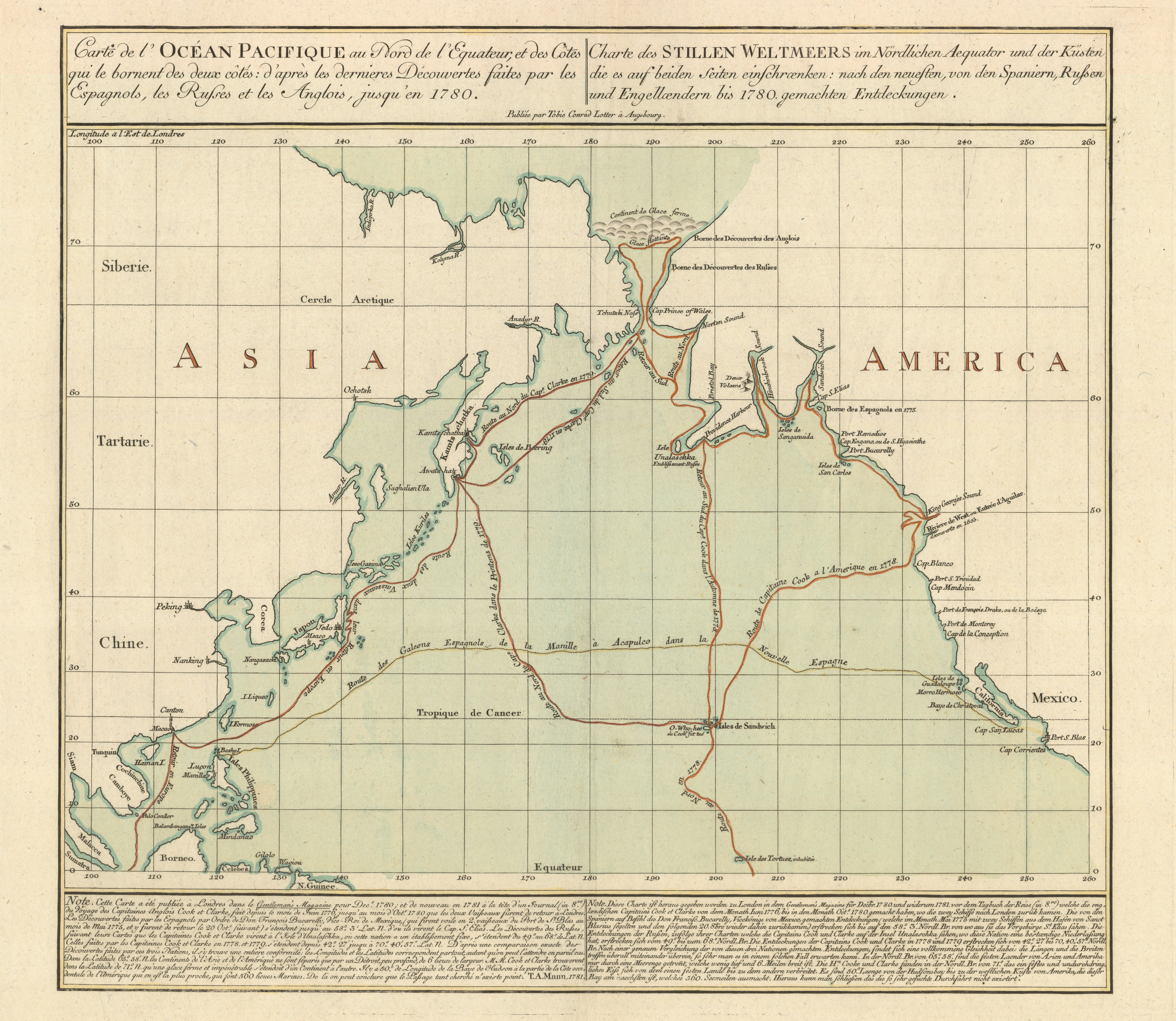
Lotter, Tobias Conrad, 1717–1777. “Carte de l’Océan Pacifique au nord de l’equateur, et des côtes qui le bornent des deux côtes: d’après les dernieres découvertes faites par les Espagnols, les Russes et les Anglois, jusqu’en 1780” (Augsburg, 1781.)Copperplate map, with added color, 42 × 50 cm. on sheet 59 × 73 cm. [Historic Maps Collection]
An historic document: the first published map to show Cook’s third voyage and the first map to show Hawaii.
Scurvy-Proof
Every innovation whatever tho ever so much to their advantage is sure to meet with the highest disapprobation from Seamen, Portable Soup and Sour Krout were at first both condemned by them as stuff not fit for human being[s] to eat. Few men have introduced into their Ships more novelties in the way of victuals and drink than I have done; indeed few men had the same opportunity or been driven to the same necessity. It has however in a great measure been owing to such little innovations that I have always kept my people generally speaking free from that dreadful distemper the Scurvy. [Journals, p. 595]

Comparison: “Plan de la Baye de Karakakooa,” from Rigobert Bonne’s “Carte des Isles Sandwich” (1788?)—this is a French copy of Cook’s 1779 chart—inset within “Kealakekua Bay to Honaunau Bay” (1998), chart no. 19332 of the coastal survey of the U.S. National Oceanic and Atmospheric Administration’s National Ocean Service. [Map Library, Princeton University]

“A View of Karakakooa [today’s Kealakekua], Owhyee”: site of Captain Cook’s death. From the atlas volume.
Karakakooa Bay is situated on the West side of the island of Owhyhee, in a district called Akona. It is about a mile in depth, and bounded by two low points of land, at the distance of half a league, and bearing South South East and North North West from each other. On the North point, which is flat and barren, stands the village of Kowrowa; and in the bottom of the bay, near a grove of cocoa-nut trees, there is another village of a more considerable size, called Kakooa: between them runs a high rocky cliff, inaccessible from the sea shore. . . . The shore, all round the bay, is covered with a black coral rock, which makes the landing very dangerous in rough weather; except at the village of Kakooa, where there is a fine sandy beach, with a Morai, or burying-place, at one extremity, and a small well of fresh water, at the other. This bay appearing to Captain Cook a proper place to refit the ships, and lay in an additional supply of water and provisions, we moored on the North side, about a quarter of a mile from the shore. . . . [vol. 3, pp. 1–2]

“An Offering before Capt. Cook in the Sandwich Islands.” From the atlas volume.
On his arrival at the beach, he was conducted to a sacred building called Harre-no-Orono, or the house of the Orono, and seat before the entrance, at the foot of a wooden idol, of the same kind with those of the Morai. I was here again made to support one of his arms, and after wrapping him in red cloth, Kaireekeea, accompanied by twelve priests, made an offering of a pig with the usual solemnities. The pig was then strangled, and a fire being kindled, it was thrown into the embers, and after the hair was singed off, it was again presented, with a repetition of the chanting. . . . The dead pig was then held for a short time under the Captain’s nose; after which it was laid, with a cocoa-nut, at his feet, and the performers sat down. The ava was then brewed, and handed round; a fat hog, ready dressed, was brought in; and we were fed as before. During the rest of the time we remained in the bay, whenever Captain Cook came on shore, he was attended by one of these priests, who went before him, giving notice that the Orono had landed, and ordering the people to prostrate themselves. [vol. 3, pp. 13–14]
The crowds were massive, and the ships were swarmed. The atmosphere was both euphoric and hysteric. Cook’s arrival, its timing and manner, mirrored the narrative of a traditional Hawaiian myth regarding Lono makua, the god of Hawaii’s season of abundance: Lono would appear in a great canoe at this season, circle the island clockwise, and enter this bay, Kealakekua, “the path of the gods.” The remarkable coincidence probably accounts for the welcoming-god treatment Cook initially received, though some scholars recently have argued against that interpretation. Several chiefs and a high priest named Koa arrived and restored some order, then led Cook ashore to an elaborate ceremony near a morai, or place of worship. The hysteria diminished in the days that followed; trading, salting and storing hogs, and ship repair work continued. King Kalei’opu’u, whom they had met and whose rank they had underestimated on Maui—he was actually king of all Hawaii—made his regal approach days later and gave Cook his own cloak, while the common natives prostrated themselves in veneration. But Cook was keen to get away and continue his exploration, and the islanders appeared anxious for Lono to return to his heavenly abode.
Before leaving on February 4, Cook and King had been given personally by King Kalei’opu’u an astonishing and valuable amount of vegetables and pigs, exceeding anything they had received anywhere. Also, one of Cook’s old sailor hands, William Watman, had died and received a ceremonial burial at the morai; and strangely, Cook had asked and gotten permission from Koa to dismantle the decorative fencing around the morai to use for kindling. (Was that disrespectful?) Then the ships left, while the whole population lined the rocks and promontories of the bay, waving white cloths. But a fierce storm, a few days later, split the Resolution’s foremast, and Cook, reluctant but resigned, decided to return to Kealakekua Bay for its repair.Whether the captain god had outworn his welcome or somehow was angering Hawaiian spirits, his return was not viewed happily by either side, crew members or islanders. Instead of hysteria, the ships were greeted with silence; daggers seemed the only valuable trading currency now. As repair of the mast was underway, the Hawaiians seemed restless and provocative. Blatant thefts occurred, stone-throwing incidents developed, and Cook ordered his men to load their muskets with balls instead of shot.
On the morning of Sunday, February 14, the Discovery’s watch officer discovered that the large cutter had been stolen. Informed of this serious matter, Cook determined not to let the Hawaiians get the upper hand, and strategized to kidnap the main chief and hold him hostage until the stolen item was returned. The bay was blockaded, and events unfolded quickly. Williamson commanded the Resolution’s launch, Bligh the small cutter; armed island warriors, wearing protective mats, lined the black cliff top. Some skirmishes took place on the water and the southern shore. In the pinnace, Cook took ten marines to Kaawaloa, Kalei’opu’u’s village on the northern shore of the bay. He woke the chief, explained the matter, and finally all started toward the shore—but word reached the gathering crowd that an important chief had been killed on the other side, where the carpenters were working. Stones were thrown, men knocked down, muskets fired, and then a panic-stricken retreat to the boats was made by Cook’s men. At some point Cook, who had been walking slowly to the water, gave a signal with his hand (to a boat to come in? to stop firing?). He was stoned, clubbed, and then a dagger—ironically, one that had been traded to the natives—came out and struck him in the back of the neck. The frenzied crowd descended. Williamson, who was the closest in the launch, might have attempted to save his captain but refused to aid in his defense and kept off the shore. Like Magellan’s, Cook’s was an ignoble death at the water’s edge. Four of the marines were also killed. All of the bodies were left behind as the boats, with their wounded, returned to the ships in the bay.
By noon, Bligh had taken a party in revenge and assaulted the Kealakekua village on the southern shore; every crew member from there, with the half-repaired mast, had been evacuated. As Clerke, who was now commander of the expedition, demanded of Koa, the recoverable part of Cook’s body was delivered to the Resolution the following day; several days later, some of his additional bones were given with gifts of peace. These few remains of Cook were committed to the deep of the bay on February 22, bells tolling and cannons firing. The despondent men and ships departed from Hawaii the next morning.
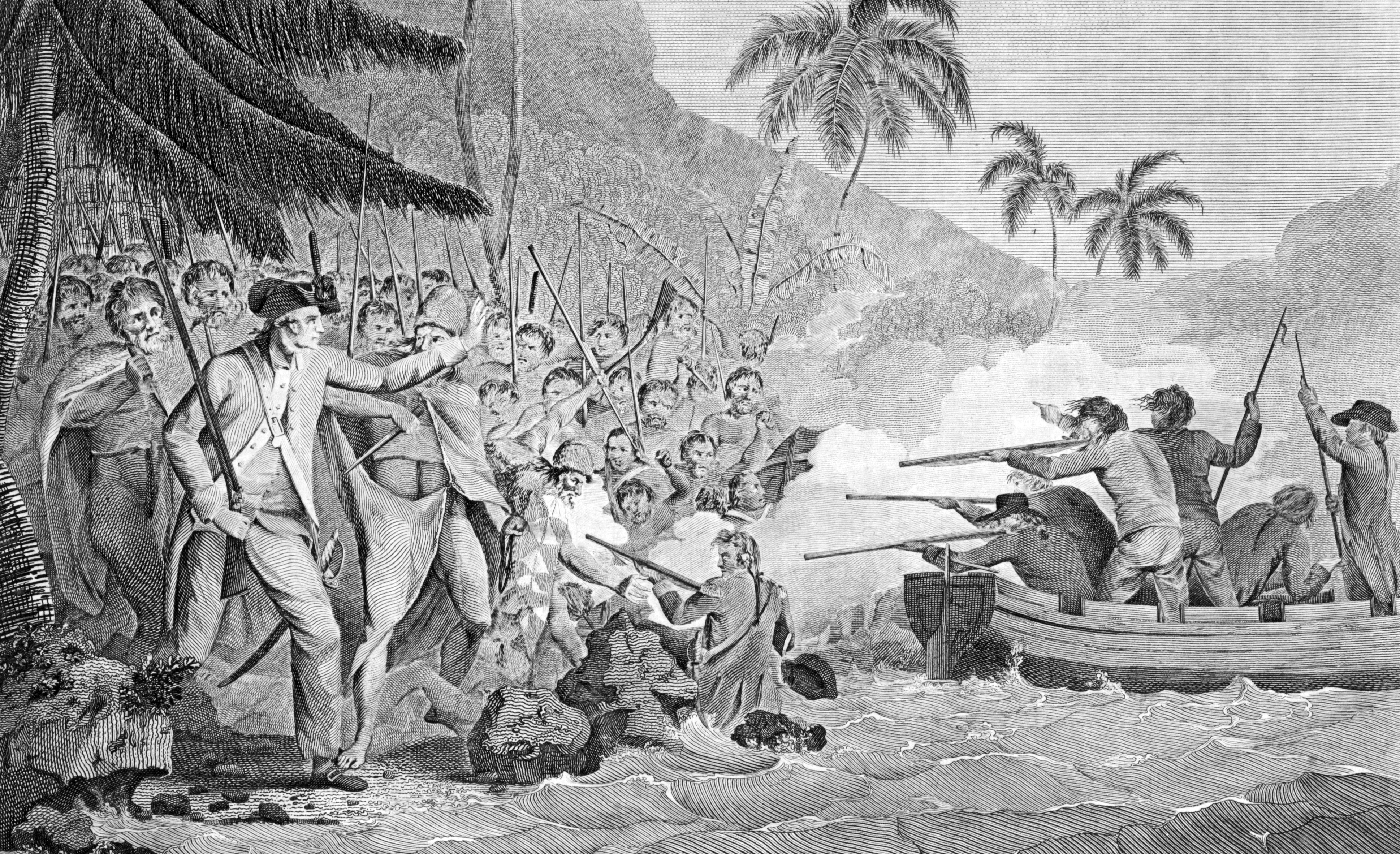
“An Exact Representation of The Death of Captn. James Cook, F.R.S at Karakakooa Bay, in Owhyhee, on Feby. 14, 1779.” From George William Anderson’s A New, Authentic, and Complete Collection of Voyages Round the World, Undertaken and Performed by Royal Authority . . . Captain Cook’s First, Second, Third, and Last Voyages . . . (London, 1784). [Rare Books Division]

Monument to Cook, erected in 1874 on the site of his death, viewed in 2009. [Photograph courtesy of John Delaney]
Resolution and Discovery arrived back in the Thames on October 4, 1780—after one more valiant try at discovering a Northwest Passage. On the way, Bligh surveyed the rest of the Sandwich Islands. The expedition reached Petropavlosk by May and was through the Bering Strait by July 6, but the ice field was indomitable, on both sides, beyond 70°33′, a few miles short of Cook’s record, so they headed south. When Clerke succumbed to his tuberculosis on August 22, near the Kamchatkan coast, Gore assumed command and King took over the Discovery. All the officers consulted and agreed to return home via the little-known eastern Asian coast and Japan (which they ultimately missed because of gales), visit Canton (China) for supplies, avoid Batavia, and then proceed directly to the Cape of Good Hope and home. Back in England, the Admiralty already had heard of Cook’s death (from Clerke’s letter sent while in Russia) in January of that year, and the sad news and grief had swept the country, so there was no huge excitement about the expedition’s return in the fall. No distribution of £20,000. But the machinery of Cook myth-making had begun cranking up.
Elizabeth Cook survived her husband by fifty-six years, yet she had to suffer additional tragedies—the loss of all of her sons, two at sea, one from infection at school. (Like Magellan, Cook would have no heirs.) But she did live to see the Industrial Revolution, toward which her husband’s voyages had been sailing with their scientific treasure troves.
Cook’s published journal (A Voyage to the Pacific Ocean) ends hopefully and triumphantly:
|
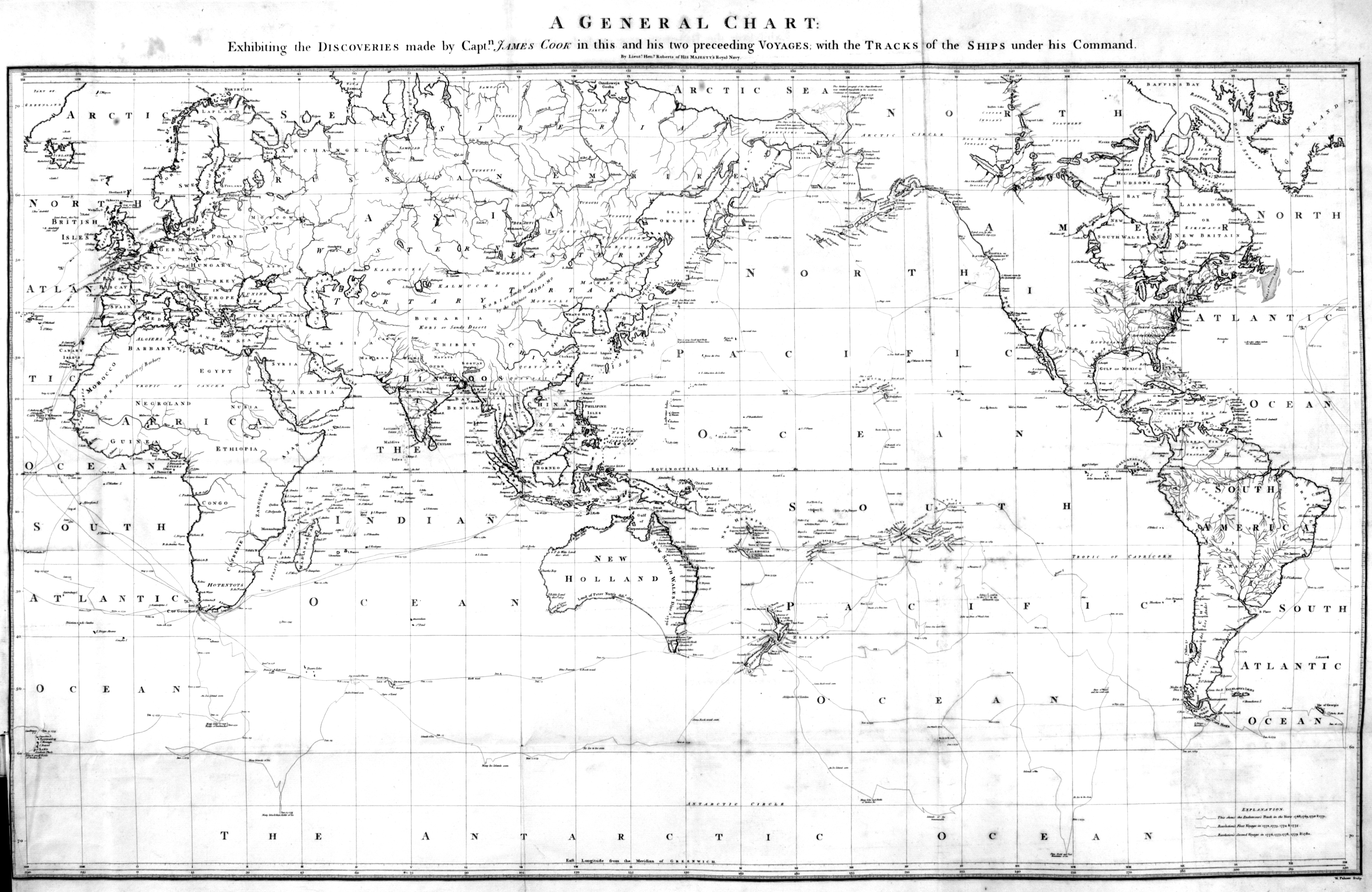
“A General Chart: Exhibiting the Discoveries Made by Captn. James Cook in This and His Two Preceeding Voyages, with Tracks of the Ships under His Command.” Copperplate map, 36 × 57 cm. From the atlas volume of Cook’s A Voyage to the Pacific Ocean . . . (London, 1784). [Rare Books Division]
Cook’s legacy: a revealed world. His world map was the most accurate at its time. During his life, he had explored farther north (70°44′ N) and farther south (71°10′ S) in the Pacific than any previous human being.