Francesco Colonna, d. 1527. Untitled woodcut map [“Isola di Cithera”], 13.5 cm in diameter. From Colonna’s Hypnerotomachia Poliphili (Venice: Aldus Manutius, Romanus, Dec. 1499) [Kane Collection, Rare Books Division].
“All human things are but a dream” states the preamble. This anonymous book (called in English “Polipho’s Strife of Love in a Dream”) is a fine example of early printing, the most lavishly illustrated incunable from Venice. Its romantic allegory, in which classical mythology figures prominently, was translated into French and English in the 1500s and remained popular well into the seventeenth century. From an acrostic formed from the elaborate first letter of each chapter, the work has been attributed to Colonna, a Dominican priest and monk who lived in Venice and preached at St. Mark’s Cathedral.
In this part of his dream, Polipho and his love, Polia, take a barge, piloted by Cupid, to the island of Cythera, illustrated here in a woodcut map. The pie-shaped island is shown divided into equal slices, which are circled by alternating rows of groves, fields, colonnades, and hedges. Twenty paths from the shore (littore) converge at the center, where the fountain of Venus is concealed, we are told, by a sacred trellis structure. All of the design reflects Renaissance principles of perspective, and the text provides exacting measurements of its geometry. For example, the island’s circumference is given as “tre milliarii” and its diameter as “uno milliario,” a ratio that approximates the mathematical constant of pi.
Curiously, but appropriately in our mapping context, the work’s elegant woodcut illustrations recently have been attributed to Italian editor and cartographer Benedetto Bordone (1460–1531) of Isolario fame.

>
Portrait of Madeleine de Scudéry, 1607–1701. From vol. 2 of C. A. Sainte-Beuve’s Portraits of the Seventeenth Century, Historic and Literary, trans. Katharine P. Wormeley (New York: G. P. Putnam’s Sons, 1904) [General Library Collection].
A French author of lengthy, conversational novels, Scudéry, commonly known as Mademoiselle de Scudéry, was a well-educated intellectual who started her own salon, Société du samedi (Saturday Society). She is considered to be the first “bluestocking” woman of France, predating her more famous English counterparts (Elizabeth Montagu et al.) by more than a century.

[Above] Untitled copperplate map [“Carte de tendre”], 20 × 29.5 cm. From vol. 1 of Scudéry’s Clélie: Histoire romaine dediée à Mademoiselle de Longueville (Paris: A. Courbé, 1654–1661) [Rare Books Division].
It is probably not surprising that Scudéry’s map on love was originally conceived as a social game and only later incorporated into her romance Clélie. As geographer, Scudéry provides three different routes (or stages) for a woman to follow to the city of “Tendre” from her starting point, the city of New Friendship (“Nouvelle amitié”), given at the bottom of the map: along three different rivers, named Recognition, Esteem, and Inclination. (I’m not convinced that Scudéry’s ideas, as expressed in the novel, are precisely depicted on the map, but one gets the general idea.) Departing on Inclination River, the main conveyance, she can pass by such towns as Fresh Eyes, Love Letter, Big Heart, and Generosity; on the other side of the river, the towns include Complacence, Little Care, Attendance, and Obeisance—alternating, it seems, between simple passions and social virtues. Constant Friendship (on the left) and Goodness (on the right) complete the other routes she might take. Beyond Tendre a woman should not venture, according to Scudéry, for a Dangerous Sea and Unknown Territory await. Similarly, deviating from New Friendship (left or right) will only bring a woman past places such as Indiscretion, Perfidy, and Wickedness, ending at the Sea of Enmity or the Lake of Indifference. Notice that “marriage” is not present in the map; its absence reinforces Scudéry’s view that women should be emancipated from matrimony, as her heroine becomes in the novel—indeed, as her own name (“Mademoiselle”) suggests.
The map was so popular, and widely debated, that Scudéry is often credited with originating this allegorical map genre.

Portrait of Eustache Le Noble, 1643–1711. From his Contes et fables, ou L’esprit du sage (Paris: Chez Michel Brunet, 1697) [Kenneth McKenzie Fable Collection, Rare Books Division].
French author Eustache Le Noble produced a large number of pamphlets, stories, fables, histories, and translations of an entertaining but, mostly, mercenary nature during an adventurous life of travel and dissipation. He was imprisoned in La Conciergerie (Queen Marie Antoinette’s prison) for forging documents, and penned many of his works there. One of his better-known publications in English is titled, ironically (ruefully?), The Art of Prudent Behaviour, in a Father’s Advice to His Son, Arriv’d to the Years of Manhood. The caption under his portrait amusingly opines: “bark low” to keep your reputation.

[Above] “Carta dell’isola del maritaggio.” Copperplate map, 22.5 × 34 cm. From Le Noble’s Carta topografica dell’isola del maritaggio di Monsieur Le Noble; per la prima volta tradotta dal francese in italiano (Cosmopoli: s.n., 1765) [Rare Books Division]. This book was the first Italian printing of Le Noble’s Carte de l’isle de mariage (Amsterdam, 1705).
The book’s text offers instructions on how to reach this matrimonial island and describes the living options on it. The map’s latitude and longitude scale place the island in the general area of Madagascar—far enough away from Europe to be exotic, but still “real.” The island’s central province is named Cornovaglia, or Great Province of Cuckolds (see the horned figure in the cartouche), and its heart is a great fortress whose largest ramparts point to the Port of Love as if prepared for perpetual attacks from that direction. The River of Covenant (symbolizing marriage vows?) runs through it as a constant, but fluid presence. To the north is the land of Jealousy with its peninsula of Divorce and Mountains of In-laws; to the south live the Discontented; to the west, the Malacopiati, or Incompatibles, with a peninsula for the Widowed. The Chaste River flows through the province of the Wise in the east, which shelters the Port of Love. Across an active, navigable channel lies a large Lovers Island, which neighbors Bigamy Island.
The imagery here is much more pessimistic than Scudéry’s, presenting a sobering, if not negative, view of conjugal life, obviously colored by Le Noble’s amatory experiences. “What are the advantages for a man,” seems Le Noble’s question, “who becomes a watchman constantly on the lookout for his usurper?” (Perhaps this is the reason Scudéry’s map ignores matrimony altogether.)
 >
>
Portrait of Matthaeus Seutter, 1678–1756. From Hans
Harms's Künstler des Kartenbildes: Biographien und Porträts
(Oldenburg (Oldb): E. Völker, [1962]) [courtesy of Ernst
Völker].
Matthaeus Seutter was a talented German mapmaker of the early eighteenth century, who had apprenticed as an engraver in the print shop of esteemed countryman Johann Baptist Homann. Many of his maps were based on, or copied from, other cartographers, including Homann. [For more on Homann, see the following Utopia section.]
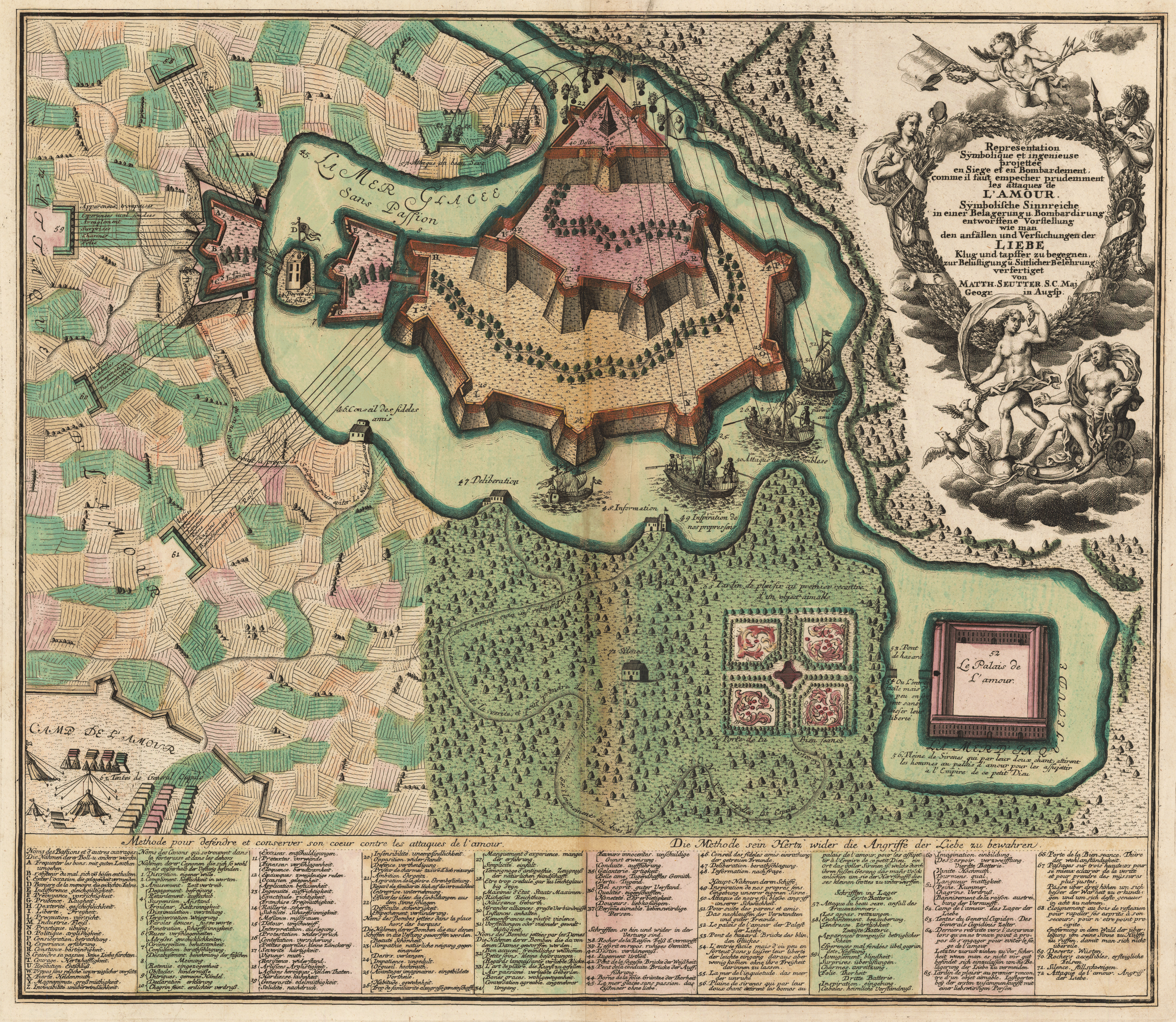
[Below] “Representation sÿmbolique et ingenieuse projettée en siege et en bombardement comme il faut empecher prudemment les attaques de l’amour” ([Augsburg: M. Seutter, ca. 1730]). Copperplate map, with added color, 40 × 56 cm [Historic Maps Collection]. Title, captions, and key in both French and German. Reference: Hill, Cartographical Curiosities, 65.
The concept of the fortified heart is taken to the extreme in this richly engraved and embellished map by Seutter. The large cartouche shows Venus in her chariot being pulled by flying birds through clouds. Depicted below, as it were, a sophisticated battle scene (with ninety-five keyed features) unfolds, where forces are attacking and defending the fortress of Manhood that sits in a frozen, passionless sea. The side of Love, representing the fairer sex, employs four sets of artillery batteries (on the left) to bombard the walls with appeals to vanity, offering delightful surprises, charms, and joys, and plying with tenderness, wishful thinking, and “un certain je ne sais quoi.” Over the walls, naval ships lob such feminine wiles and virtues as beauty, pleasant conversation, gentleness, and “regards languissant” (languishing looks). Love’s forces are camped for the duration (at the lower left), commanded by their general, Cupid.
As the key states, there are also methods for defending and conserving one’s heart against this unrelenting onslaught: memory, prudence, industry, experience (see the lettered outposts along the fortress walls). Ultimately, however, it is a war of attrition. As the trail winding through the fortress and along the coastline proves, the love-struck victim surrenders, retreating, first, to his friends for advice, deliberation, and information, before moving onward to the garden of pleasure and his first encounter with his beloved. (Seutter’s ornate and symmetrical “Jardin de plaisir” reflects the precisely structured love bower of Colonna.) From there, via a subterranean passage, he arrives at the Palace of Love—note the change from fortress to palace—which resides in a sea of peace. Entering is easy, according to the note, but leaving is impossible without losing one’s liberty. Another definition of a prison?
>
Portrait of Johann Gottlob Immanuel Breitkopf, 1719–1794. From Hans Wahl’s Goethe und seine welt; unter mitwirkung von Ernst Beutler herausgegeben von Hans Wahl und Anton Kippenberg (Leipzig: Insel-verlag, 1932) [General Library Collection].
Johann Gottlob Immanuel Breitkopf was a German music publisher and typographer who revolutionized the printing of music with moveable type.
[Left, bottom] “Das Reich der Liebe: Zweyter Landchartensatz-Versuch” (Leipzig: Aus Breitkopfs Buchdr., 1777). Printed map, with added color, 18 × 23 cm. [Historic Maps Collection]. From Breitkopf’s Beschreibung des Reichs der Liebe, mit beygefügter Landcharte: Ein zweyter Versuch im Satz und Druck geographischer Charten, durch die Buchdruckerkunst (Leipzig: Aus der Breitkopfischen Buchdruckerei, 1777). Reference: Hill, Cartographical Curiosities, 66.
Breitkopf was the first to apply his printing method to maps; at least three test maps are known, of which this “Kingdom of Love” is one example. Note that everything in this map, including the river lines, was printed with type. The method proved cumbersome and time-consuming, and was discontinued. But that did not deter Breitkopf from having fun with his subject.
On the left side of the map lies the country of those who believe in the power of love, bordered by the hopeless mountains; on the right is the country of bachelors, which is home to villages of stupidity and scandal. In the map’s center sits a region of fixed ideas, where, among others, the restless live. At the bottom is the land of youth, where beautiful, carefree residents joke, kiss, and make wishes. Calm, reasonable sleepyheads (grandpas) live next door (bottom right). The largest territory (rosy-colored!), bordering the land of lusts, is for happy lovers, who feel secure, listen to each other, and evince a cheerful prospect—a place beneficial for children. Divorced, unwelcoming brawlers inhabit the drab region at the top center.
The map appeared in the midst of the Sturm und Drang (“turbulence and urgency”) period (1760s–1780s) of German literature and music, which emphasized self-expression and extremes of emotion.
