
New Jersey Counties: First Wall Maps and Atlases
Atlantic County
| County Data | |
| Founded: 1837, from the eastern part of Gloucester County |

|
| Total Area: 671 square miles | |
| Population: 11,786 (1860); 274,549 (2010) | |
| County Seat: May's Landing | |
| Largest City: Atlantic City |
1872: County Wall Map
![F. W. Beers. "Topographical Map of Atlantic Co., New Jersey, from Recent and Actual Surveys under the Direction of F.W. Beers" (New York: Beers, Comstock & Cline, 1872) [Library of Congress]. Wall map, with added color, 171 × 161 cm. Scale: 200 rods to 1 inch. (No county atlas was published; see the "New Jersey Coast" section for more coverage of the county's shore communities.)](https://libimages.princeton.edu/loris2/exhibits%2Fnj-historic-maps%2Fatlantic%2F1872-atlantic-countywall-map.jp2/full/!750,750/0/default.jpg)
First wall map of Atlantic County. Yellow, pink, and blue colors identify seven individual townships: Buena Vista, Egg Harbor, Galloway, Hamilton, Hammonton, Mullica, and Weymouth. Green highlights the incorporated cities of Absecon (1872), Atlantic City (1854), and Egg Harbor City (1858). The central county map is surrounded with detailed plans—on scales from 15 to 60 rods to 1 inch—of the region's major villages, towns, and cities (_in clockwise order from top left_): May's Landing, Atsion, Egg Harbor City (450 feet to 1 inch), Conoverville, Port Republic, Smithville, Absecon, English Creek, Leedsville, Bargaintown, Mount Pleasant, Pleasantville, Risleysville, Smith's Landing, Leeds Point, Bakersville, Atlantic City (400 feet to 1 inch), Hammonton, Weymouth, and Elwood. "Business Notices" for several of the communities are provided, as well as population statistics for the state (by county) from 1790 through 1870. Separate statistics for Atlantic and Ocean Counties enumerate "white" and "colored" residents.
One senses that the numerous proposed (dotted lines) and unnamed roads laid out in the empty areas of the townships anticipate rapid development. There are two main railroad lines: the Camden & Atlantic Railroad bisects the county diagonally (northeast/southwest); the Vineland Railroad enters and exits at top left. The spur shown joining May's Landing with Egg Harbor City was completed in 1871 by the Egg Harbor & May's Landing Railroad. What is absent from the map is also intriguing: Absecon and Brigantine beaches are inaccessible, hence completely undeveloped.
◊ ◊ ◊

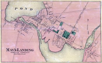
The green square on Main Street near the river shows the brick edifices of the surrogate's office, the courthouse, and the clerk's office. Built in 1838, they were renovated in 1978.
1834: Mays Landing, p-t of Hamilton t-ship, Gloucester co., upon the Great Egg Harbour river, at the head of sloop navigation, 16 miles from the sea, 35 miles S.E. from Woodbury, 73 from Trenton, and 181 N.E. from W.C.; built on both sides of the river, including the village of Hamilton, and contains 3 taverns, 4 stores, a Methodist church, and 25 or 30 dwellings; a considerable trade in cord-wood, lumber, and ship building, is carried on at this place [Gordon, p. 175].
1886: City Fire Insurance Maps
![1886: City Fire Insurance Maps. Sanborn Map Company. "Atlantic City New Jersey Dec. 1886&qout; (New York: Sanborn Map & Publishing Co., Limited, 1886) [Historic Maps Collection]. Lithograph map, on sheet 63.4 × 53.4 cm. Combination title, index, and overview sheet.](https://libimages.princeton.edu/loris2/exhibits%2Fnj-historic-maps%2Fatlantic%2F1886-atlantic-city-sanborn-title-map.jp2/full/!320,320/0/default.jpg)
Located on Absecon Island in Atlantic County, Atlantic City has been a major American summer playground since it formally opened in 1880. It was the inspiration behind the popular board game Monopoly. Since gambling casinos were introduced in the late 1970s, the city has become a popular year-round resort.
Founded in 1867 by the young surveyor D. A. Sanborn, the Sanborn Map Company became synonymous with large-scale fire insurance maps of commercial, industrial, and residential areas of American towns and cities. Its virtual dominance of the market ended soon after World War II, as the insurance industry's needs changed. Princeton University Library's Historic Maps Collection has digitized its holdings of more than sixteen thousand historic Sanborn maps of New Jersey communities, ranging in date from 1884 to 1950. Access to the high-resolution images is free.1 Color-coded to show building material (such as frame, brick, stone, or iron)—and providing the size and footprint of each structure at its signature scale of 50 feet to 1 inch—the maps are frequently used today in historical preservation, restoration, and development projects.
Under the title of this Atlantic City page, several key factors relevant to fire insurance assessment are briefly noted: population (30,000 residents), water facilities and system capacity, and fire department (280 members) and equipment. (The dozens of hotels named here, visited by hundreds of thousands of visitors annually, were constant fire hazards, and a number of disastrous fires ravaged the city through the middle of the twentieth century.) The index at the top identifies the map sheet (numbered 2–38) associated with a street address (under "Streets') or a business (under "Specials"). The index map at the bottom provides an overview of the layout and scope of the individual map sheets: an alternative way for one to find the specific map sheet that covers a geographical area of interest.
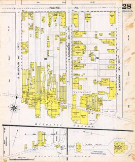
The adjacent map is sheet 28 of this 1886 Atlantic City series, showing the area bordered by the Atlantic Ocean and Pacific, South Missouri, and South Michigan Avenues, as well as the extent of the Iron Pier that juts into the ocean from the bottom of South Massachusetts Avenue. Erected on iron pilings, this pier had just opened in the spring and featured rides and exhibits along its length, with a large theater on the ocean end. (It was the city's first ocean pier, and was razed in 1945.) Landmark hotels in this part of the city included the Shelburne and the Fortescue, both of which had long lives as luxurious destinations for tourists. (The Shelburne site is now occupied by Bally's Wild Wild West Casino.) Nearby, in a building over the water, was the "Punch & Judy Show": an ever-evolving puppet show, primarily for children, that had its origins in seventeenth-century England; local versions were often found at many seaside, carnival, and festival venues. Note that all of the structures are colored yellow, indicating that they were constructed of wood.