
New Jersey Counties: First Wall Maps and Atlases
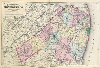
Monmouth County
| County Data | |
| Founded: 1683, one of the four original counties of East Jersey |

|
| Total Area: 665 square miles | |
| Population: 39,346 (1860); 630,380 (2010) | |
| County Seat: Freehold Borough | |
| Largest City: Middletown |
1851: County Wall Map
![Jesse Lightfoot. "Map of Monmouth County New Jersey from Original Surveys" (Middletownpoint, [N.J.]: J. B. Shields, 1851Middletownpoint [N.J.] : J.B. Shields, 1851) [Library of Congress]. Wall map, with ornamental border, 99 × 138 cm99 X 138 Cm. Scale: 1 mile to 1.5 inches.](https://libimages.princeton.edu/loris2/exhibits%2Fnj-historic-maps%2Fmonmouth%2F1851-monmouth-county-wall-map.jp2/full/!750,750/0/default.jpg)
First wall map of Monmouth County. It includes detailed plans of Freehold, Keyport, Middletown Point (today's Matawan), and Red Bank. Large bold capital letters name the twelve townships, and dotted lines mark their borders: Atlantic, Freehold, Howell, Manalapan, Marlborough, Middletown, Millstone, Ocean, Raritan, Shrewsbury, Upper Freehold, and Wall. Smaller capitals name the towns and villages, as well as several major roads and geographic features. The sheet is embellished with fourteen engravings: four churches, 95 X 95 Cmfive private residences, a hotel (Freehold), a boarding house (Deal), a ladies seminary (Freehold), county buildings (Freehold), and a beach boarding house (Long Branch).
1834: Long Branch, well known and much frequented sea-bathing place, on the Atlantic ocean, 75 miles from Philadelphia, and 45 from New York, in Shrewsbury t-ship, and Monmouth co., which has its name from the stream and hamlet above. The inducements to the invalid, the idle, and the hunters of pleasure, to spend a portion of the hot season here, are many. Good accommodations, obliging hosts, a clean and high shore, with a gently shelving beach, a fine prospect seaward, enlivened by the countless vessels passing to and from New York, excellent fishing on the banks, 3 or 4 miles at sea, good gunning, and the great attraction of all watering places, much, and changing and fashionable company. During the season, a regular line of stages runs from Philadelphia, and a steamboat from New York, to the boarding houses here, of which there are several; Wardell's, Renshaw's, and Sear's are the most frequented. Many respectable farmers also receive boarders, who, in the quiet of rural life, enjoy in comfort and ease, their season of relaxation, perhaps more fully than those at the public hotels. Along the beach at Long Branch is a strip of fertile black sand, several miles in length, and exceeding more than a mile in width. The land adjacent to the ocean rises perpendicularly from the beach, near 20 feet. The boarding houses are 20 rods from the water, with lawns in the intermediate space. The high banks are formed by strata of sand, clay, and sea mud [Gordon, p. 170].
Long Branch is where President James A. Garfield was brought for recovery in September 1881 after he was shot in Washington, D.C., on July 2; he died there on September 19.
Much of the county is shown on the map to be wooded, particularly in the south and near the coast.
The county's peninsular finger pointing to New York City, Sandy Hook ("Sant Punt" or "Sant Hoek" on early Dutch maps), is the "Property of the United States." Visited by Henry Hudson in 1609, much of the area is now managed by the National Park Service as part of the Gateway National Recreation Center. (For more on Sandy Hook, see the "New Jersey Coast" section.)
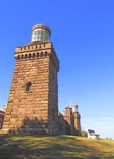

Located opposite Sandy Hook on the mainland, the twin towers of the Navesink Lighthouse rest on one of the highest points along the entire eastern seaboard.
The site of the American Revolution's Battle of Monmouth (June 28, 1778) is given under the third A in "Manalapan" along the Englishtown-Freehold Road.
From this vantage point, Continental Army artillery enfiladed British troops as they attempted to drive back the American line in the west (left). With temperatures over 100° F., many succumbed to heatstroke in the fierce fighting. The myth of Molly Pitcher carrying water to thirsty troops has some basis in fact in this battle. Mary Hays, wife of an American artilleryman in the battle, carried water to men and swabbed the hot cannons to cool them. At nightfall, the armies had fought to a standstill, and the British retreated to Sandy Hook in the darkness. That Continental regiments could hold their ground against British regulars gave General Washington tremendous confidence as the war progressed. The battlefield is one of the best preserved from the Revolutionary War.
1873: County Atlas
![F. W. Beers. Atlas of Monmouth Co., New Jersey: From Recent and Actual Surveys and Records (New York: Beers, Comstock & Cline, 1873) [Historic Maps Collection]. 121 pp., including maps.](https://libimages.princeton.edu/loris2/exhibits%2Fnj-historic-maps%2Fmonmouth%2F1873-title-page.jp2/full/!320,320/0/default.jpg)
First atlas of Monmouth County. The volume consists of a map of the United States and the county, maps of fourteen townships and forty-six towns and villages, a map of Fair View Cemetery (Middletown Township), a table of distances and other statistics, and the 1870 census for the state by township.
Grown to fourteen in number, the townships are colored in blue, yellow, pink, or orange: Atlantic, Freehold, Holmdel, Howell, Manalapan, Marlboro, Matavan, Middletown, Millstone, Ocean, Raritan, Shrewsbury, Upper Freehold, and Wall. The four municipalities of Freehold (1869), Long Branch (1867), Red Bank (1870), and Keyport (1870) are green. (Matavan was renamed Matawan in 1882, which then became Aberdeen Township in 1977.) Transportation modes are well developed, for roads and railroads are prominent, including several proposed lines. The Monmouth County Agricultural Railroad, a short line linking Freehold with Keyport, began in the 1860s, carrying inland farmers' produce, marl fertilizer, and manufactured goods to the railroad pier in Keyport. The rail bed is currently leased by New Jersey Transit to the Monmouth County Park System for recreational use as part of the Henry Hudson Trail.
◊ ◊ ◊

The New Jersey Southern Railroad, vertically bisecting the map, was the former Raritan and Delaware Bay Railroad. The R&DB was chartered in 1854 to build a line from Raritan Bay to Cape May; by 1860 it had opened service from the bay to Eatontown and, by a branch, to Long Branch on the shore. With a length of five thousand feet, the wharf shown on the map extending well into Sandy Hook Bay was one of the railroad's great engineering accomplishments. The outline of a planned pentagon-shaped fort is visible at the tip of Sandy Hook. Army engineers began building the massive walls in 1859; when construction ceased ten years later, approximately 70 percent was completed. By then, developments in canon technology had made these types of fortifications obsolete. Note that the Sandy Hook peninsula—in contrast to its depiction on William Watson's 1812 state map—is longer now and unbroken.
Anticipating rapid growth, the township realized its church cemeteries would not be sufficient, and laid out Fairview Cemetery (shown in green) as a large park in 1851. "Garrets Hill" is the "Indian Trees" site of colonial charts. (See the 1749 New York Harbor chart in the "Historical Background Maps" section.)
◊ ◊ ◊
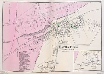
The town straddles two townships: Shrewsbury in pink, Ocean in light yellow. (Just months after the atlas's appearance, the town was incorporated as a township; in 1926, it became a borough again.) Three church properties—Methodist Episcopal, Episcopal, Baptist—are colored green. Light manufacturing enterprises include a gristmill, tannery, and carriage factory; other businesses and services are listed in the business directory on the left, including an oyster saloon.
Back to Top1834: Eaton, p-t. of Shrewsbury t-ship, Monmouth co., 2 miles S. from Shrewsburytown, upon Shrewsbury river, 11 miles from Freehold, 48 from Trenton, and 213 from W.C., on a branch of Swimming river, 1½ miles above navigable water; contains about 30 dwellings, 5 or 6 stores, 2 taverns, a grist mill, and an academy, in a pleasant and fertile country [Gordon, p. 134].