New Jersey Counties: First Wall Maps and Atlases
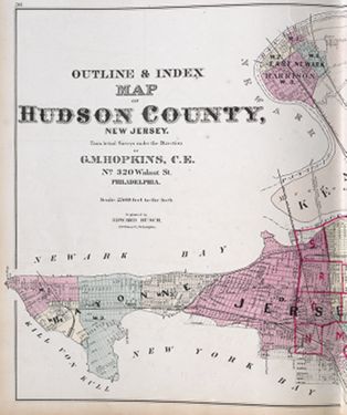
Hudson County
| County Data | |
| Founded: 1840, from Bergen County |

|
| Total Area: 62 square miles; the state's smallest county | |
| Population: 62,717 (1860); 634,266 (2010) | |
| County Seat: Jersey City | |
| Largest City: Jersey City |
1860: County Map
![Matthew Dripps. "Map of the Five Cities of New York, Brooklyn, Jersey City, Hoboken & Hudson City" (New York?: M. Dripps, 1860) [Historic Maps Collection]. "Plate No. 2." One of two lithographed map sheets, with added color, 63 x 71 cm. "Prepared by M. Dripps for Valentine's Manuel [sic] of the Corporation of the city of New York.&wuot; Scale: 2.5 miles to 1 inch.](https://libimages.princeton.edu/loris2/exhibits%2Fnj-historic-maps%2Fhudson%2F1860-hudson-county-map.jp2/full/!750,750/0/default.jpg)
One of the first large maps to include any part of Hudson County. In 1840, Hudson County was created by the New Jersey Legislature from southern parts of Bergen County; as a result, the township area labeled "Bergen" in large letters on this map is actually part of Hudson County. The dizzying absorption, dissolution, and creation of New Jersey townships (and, to some extent, counties) during the nineteenth century often made borders difficult to define and understand.
Ferry lines are indicated by dotted lines. Today's Holland Tunnel crosses under the Hudson River from Jersey City's 12th Street to Manhattan's Spring Street, essentially following the middle dotted line shown on the map. Opened in 1927, the tunnel pioneered a mechanical ventilation system that could handle the noxious carbon monoxide emissions of the cars. The three tubes of the Lincoln Tunnel (1927, 1945, 1957) connect Hudson County's Weehawken (near the top of the map) to Manhattan at Tenth Avenue between Thirty-Eighth and Thirty-Ninth Streets.
At the top left of the map, "Three Pigeons" marks the site of a former tavern that was a prominent meeting place during the American Revolution. Historically, it was used as a landmark and popular venue for special events; today, it is an intersection. "Elysian Fields," colored blue on the Hudson River side of Hoboken, is where the Knickerbockers played the New York Nine on June 19, 1846, the first organized baseball game. Hence, some claim it is the birthplace of baseball.
Note the proximity of Ellis and Bedloes Islands to Hudson County territory. The first settlers of New Netherlands named these (with the small one below them) the Oyster Islands, for the western side of the Upper New York Bay consisted of vast tidal flats, called the Jersey Flats, rich in oyster beds. The islands are closer to the mainland today, for much of that area has been landfilled, creating Liberty State Park. The federal government took ownership and control of them in the early 1800s, initially for defensive purposes. The installation of the Statue of Liberty on Bedloes Island was completed in 1886; the island became Liberty Island by an act of Congress in 1956.
D. T. Valentine's Manual of the Corporation of New York was published annually from 1841 to 1870. Illustrated with maps and prints, these volumes documented New York City government with lists of offices and officeholders, election and financial statistics, and information about social institutions and services.
1880: County Wall Map
![1880: County Wall Map. Spielmann & Brush. <em>Sanitary & Topographical Map of Hudson County, N.J.: Prepared for the National Board of Health, Washington, D.C.</em>(Hoboken, N.J.: Spielmann & Brush, 1880) [Historic Maps Collection]. Wall map, with ornamental border and added color, dissected into eight sections, bound in volume, 56 cm. Scale: 1,000 feet to 1 inch.](https://libimages.princeton.edu/loris2/exhibits%2Fnj-historic-maps%2Fhudson%2F1880-hudson-county-map-title-page.jp2/full/!320,320/0/default.jpg)
![1880: County Wall Map. Spielmann & Brush. <em>Sanitary & Topographical Map of Hudson County, N.J.: Prepared for the National Board of Health, Washington, D.C.</em>(Hoboken, N.J.: Spielmann & Brush, 1880) [Historic Maps Collection]. Wall map, with ornamental border and added color, dissected into eight sections, bound in volume, 56 cm. Scale: 1,000 feet to 1 inch.](https://libimages.princeton.edu/loris2/exhibits%2Fnj-historic-maps%2Fhudson%2F1880-hudson-county-map.jp2/full/!750,750/0/default.jpg)
First wall map of Hudson County. Created for civil engineering purposes, the map offers extraordinary detail relating to meadowland, land reclaimed from the sea, graded streets, sewers, and railroads. Small figures at the intersection of streets indicate elevations above mean high water marks, and similar figures in the bays and rivers show the depth of water, ascertained by the U. S. Coast Survey. Two lines in the water surrounding most of the land identify the extents of future development possibilities for landfilling and pier building.
Black Tom, the island above the letter "Y" in New York Bay, was used as a shipping depot; as the map shows, a causeway and railroad linked it to the mainland. At the time of World War I, the island had become a major munitions depot for the Northeast, and huge quantities of ammunition and TNT were stored there awaiting shipment to Europe. On July 30, 1916, an act of sabotage by German agents ignited the whole arsenal in an explosion of epic proportions: people as far away as Maryland and Connecticut heard the noise and thought it was an earthquake. Shrapnel damaged the arm of the Statue of Liberty, and visits to the torch have not been allowed since. (Prior to September 11, 2001, this was one of the worst acts of terrorism committed on American soil.) Later landfills merged the island with the mainland; it is now part of Liberty State Park.
Visible under the K in "Weehawken," "Duel Ground" marks the location of the most famous duel in American history. Here, on the morning of July 11, 1804, the sitting vice president, Aaron Burr, mortally wounded Alexander Hamilton, the former secretary of the Treasury. Though murder charges against Burr were ultimately dropped, his political career also died that day.
1873: County Atlas
First atlas of Hudson County. It begins with a four-page "Special Classified Business Directory," listing alphabetically by type of services offered (such as "Boots and Shoes," "Plasterer," "Saloon Keepers") the names and addresses of county businesses. The rest of the volume consists entirely of maps: a state map, twenty-one county maps, and Hudson County city/town/township maps. Twenty plates are devoted to Jersey City and five to Hoboken. Sixteen additional plates cover sections of the towns of West Hoboken and Union; Union, Weehawken, North Bergen, and Kearney Townships; the former township of Greenville (now part of Jersey City); and the city of Bayonne. Most plates are double-page.
![Title page. Note that Hopkins is described as the "author of all the Maps made for the Late Geological Survey of New Jersey." Griffith Morgan Hopkins, Jr. Combined Atlas of the State of New Jersey and the County of Hudson: From Actual Survey, Official Records & Private Plans (Philadelphia: G. M. Hopkins, 1873) [Historic Maps Collection]. 169 pp., including maps.](https://libimages.princeton.edu/loris2/exhibits%2Fnj-historic-maps%2Fhudson%2F1873-titlepage.jp2/full/!320,320/0/default.jpg)
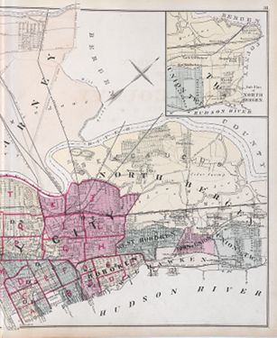
Dotted lines show the proposed extension of Jersey City streets into New York Bay. The word Meadows overlays Kearney Township (colored light orange) in two places. This region between the Passaic and Hackensack Rivers is today's Meadowlands, home of wetlands, landfills, and the Meadowlands Sports Complex. Since the time of the first Dutch settlers, the estuarine environment has suffered from various kinds of human intervention: draining, dredging, and waste disposal.
1834: Snake Hill, a noted eminence of Secaucas Island, in the marsh on Hackensack river, and a very prominent object from the road, between Jersey City and Newark. Its formation is of trap rock, on sandstone base [Gordon, p. 238].

◊ ◊ ◊
Horizontally across the map's middle, the Hackensack Plank Road parallels the track of the New Jersey Midland Railroad. Plank roads—dirt roadbeds covered with wooden planks—were developed in the nineteenth century to allow horse-drawn wagons to pass over soft or marshy ground without sinking. In New Jersey, the Hackensack, Paterson, and Newark Plank Roads were major arteries. (See Moore and Jones's Traveller's Directory [1802] description of "The Causeway," an earlier version of the concept, in the "Road Maps" subsection of "Historical Background Maps.") Bankrupted in 1875, the New Jersey Midland was sold and later consolidated with other railroads to form the New York, Susquehanna and Western Railway.
◊ ◊ ◊
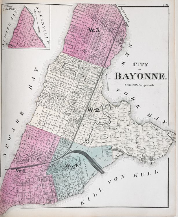
Bayonne is shown as a peninsula with two capes: Constable Hook on the east (right) and Bergen Point on the south (bottom). Over the years, large commercial piers, created by filling in the Jersey Flats, have expanded the city's breadth into Upper New York Bay.

Connecting Upper New York Bay and Newark Bay is the Kill von Krull, a tidal strait. Historically, this waterway has been crucial for marine traffic by providing access to Newark and other northeastern New Jersey ports and, thus, has required constant dredging and deepening.