
New Jersey Counties: First Wall Maps and Atlases
Bergen County
| County Data | |
| Founded: 1683, one of the four original counties of East Jersey |
|
| Total Area: 247 square miles | |
| Population: 21,618 (1860); 905,116 (2010), making it the state's most populous county | |
| County Seat: Hackensack | |
| Largest City: Hackensack |
1861: County Wall Map
![Griffith Morgan Hopkins, Jr. "Map of the Counties of Bergen and Passaic, New Jersey: From Actual Surveys" (Philadelphia: G. H. Corey, Publisher, 1861) [Library of Congress]. Wall map, with ornamental border and added color, 139 × 113 cm. Scale: 1 mile to 1.5 inches.](https://libimages.princeton.edu/loris2/exhibits%2Fnj-historic-maps%2Fbergen%2F1861-bergen-county-wall-map.jp2/full/!750,750/0/default.jpg)
First wall map of Bergen County. A thick pink line marks its border with Passaic County. At this time, Bergen had nine townships, colored blue, yellow, green, or pink: Franklin, Hackensack, Harrington, Hohokus, Lodi, New Barbadoes, Saddle River, Union, and Washington. At top right and bottom left, there are detailed insets of the three major cities of Paterson and Passaic (Passaic County), and Hackensack (Bergen County). Smaller insets (with no scales given) of twelve other boroughs/villages circle the central map (_in clockwise order_): Little Falls (P), Godwinville (B), Carlstadt (B), Bloomingdale (P), Lodi (B), Pascack (B), Hohokus (B), Englewood (B), Charlotteburg (P), Fort Lee (B), Pascack (B), West Milford (P), and Pompton Furnace (P). (The plan of Pascack appears twice.) City business directories are provided for Paterson, Carlstadt, and Passaic. Rivers, roads, and railroad lines radiate across the rudimentary topography—relief is shown by hachures, wetlands by symbols of grass growing out of water. The map locates numerous Civil War–era landowners.

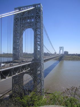
Next to the H in "Hackensack" township, at the bottom right, lies English Neighborhood, today's Englewood. During the early colonial era, this was the first primarily English-speaking area on the New Jersey side of the Hudson River. In 1817, the first baseline of the U.S. Coast Survey, charged by Congress to chart the entire American coast, was run through English Neighborhood. (For more on the Survey's role in the geodetic surveying of New Jersey, see the prior discussion of the 1888 state atlas.)
1834: English Neighborhood, pleasant village, of Hackensack t-ship., Bergen co., 5 miles S.E. from Hackensack-town, and 5½ from Hoboken, on the turnpike road to Hackensack; contains a post-office, a Dutch Reformed church, and a church of Chris-ti-ans, 3 taverns, 2 stores, and from 15 to 20 dwellings. This village is at a convenient distance from New York, by a good road, which, through a very pleasant country, affords a very agreeable drive on a summer's afternoon, to the business-worn citizens [Gordon, p. 138]. [indent]
"Tillietudlum," nearby on the Hudson River, was named for the estate of Francis Redding Tillou, who ran a ferry service to New York City from his landing (shown on the map). This area is part of today's Edgewater.
1876: County Atlas
![Title page (with view of the Palisades) of the county's first atlas. A. H. Walker. Atlas of Bergen County, New Jersey. Made from Actual Surveys of Each Township and Village, and from Historical Facts, Arranged Specially for This Work, under the Supervision of A. H. Walker (Reading, Pa.: Reading Publishing House, 1876) [Historic Maps Collection]. 167 pp., including illustrations and maps.](https://libimages.princeton.edu/loris2/exhibits%2Fnj-historic-maps%2Fbergen%2F1876-titlepage.jp2/full/!320,320/0/default.jpg)
First atlas of Bergen County. The volume contains maps of all the continents, the United States, and New Jersey; historical information about the county, townships, and villages, with a historical list of county officers; and a table of distances between county villages. The heart of the work is devoted to mapping and illustrating the county: thirteen township maps, fifty village maps, and numerous engravings of buildings, businesses, residences, and farms. These were the work of the American artist George Allen Rudd (1853–1888) who, living abroad in later years, was lost in the Alps.
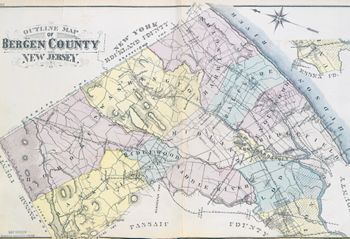
Pale pink, yellow, green, and orange colors distinguish the growing number of townships, now totaling thirteen: Englewood, Franklin, Harrington, Hohokus, Lodi, Midland, New Barbadoes, Palisade, Ridgefield, Ridgewood, Saddle River, Union, and Washington. The Ramapo, Saddle Brook, Passaic, and Hackensack Rivers traverse the map; railroad lines are equally prominent. Hatching marks along the entire Hudson River boundary of the county identify the Palisades.
The "new" northern boundary line with New York State at the top of the map ("Line Run by Professor Cook in 1874") is the result of a survey done in July and August 1874 by Professor Edward A. Bowser for the New Jersey Geological Survey and reported by George H. Cook, the state's geologist, in a report to Joel Parker, the state's governor.1 Bowser found that the original line, as traced in 1774 with a surveyor's compass (see example in the "Perspective" section), was crooked due to magnetic variations of the needle. Cook recommended that the state collaborate with New York counterparts to straighten the line and mark it with permanent monuments. This was done in 1882.
◊ ◊ ◊
Pink, yellow, green, and orange colors differentiate the school districts.
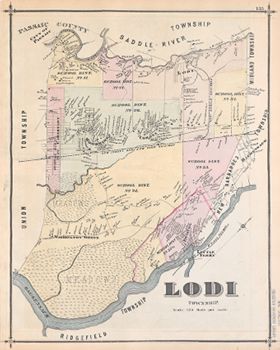
The southeastern portion is comprised mostly of salt meadow. . . . There are large erratic boulders scattered promiscuously over the many hills. . . . Lodi is celebrated for its extensive brick-yards [p. 32].
1834: Lodi, t-ship, Bergen co. . . . Greatest length 10, greatest breadth E. and W. 5 miles; area 22,000 acres; surface level. More than half the t-ship consists of salt marsh and cedar swamps. On the N.E. there are about 4000 acres of arable land, and on the west a strip running the whole length of the t-ship, and varying from 1 to 2 miles in width. These are of red shale, with a margin of alluvial, on the Passaic, well cultivated, and productive. Along the latter river are strewed many handsome country seats, and about a mile S.E. of Bellville lies the well known Schuyler copper mine. Population of t-ship, in 1830, 1356. In 1832 it contained 527 taxables, 57 householders, whose ratables did not exceed $30; 21 single men, 1 store, 5 grist mills, 4 saw mills, 2 toll bridges, and 291 horses and mules, and 931 neat cattle [= domesticated], above the age of 3 years. And it paid state tax, $208.87; county, $427.69; poor, $400; road, $500. There are several creeks through the marsh, such as Berry's, Kirkland's, and Saw-mill creeks [Gordon, pp. 169–170].
Formed in 1826, Lodi Township dissolved over time into separate boroughs and parts of other townships. What remained in 1935 became South Hackensack Township.
◊ ◊ ◊

Fort Lee is colored yellow, Taylorville (upper right) light pink. Schoolhouses, churches, and a lone cemetery are green.
Among the villages Fort Lee is uniquely interesting, for its quaint and varied architecture, its mixed native and foreign population with their busy enterprise, its original literary and professional characters, its romantic and picturesque surroundings, its important situation on the Hudson, and its Revolutionary history [p. 36].
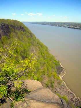
The steep cliffs of the Palisades are shown extending all along the Hudson River. From Fort Lee north, they are today part of the Palisades Interstate Park, which gained National Historic Landmark recognition in 1965.

◊ ◊ ◊

1836: Regional Map
![Thomas Gordon (1778-1848). "Map of the Bergen Meadows with the Adjoining Country" (New York: Graham & Price, 1836) [Historic Maps Collection]. Large lithographic map, 51.7 × 28.3 cm. One of two known institutional copies.](https://libimages.princeton.edu/loris2/exhibits%2Fnj-historic-maps%2Fbergen%2F1836-bergen-meadows-map.jp2/full/!750,750/0/default.jpg)
Gordon uses a dotted line and a brown tint to identify the meadowlands of Bergen and Hudson Counties.