
New Jersey Counties: First Wall Maps and Atlases
Gloucester County
| County Data | |
| Founded: 1686, boundaries established in 1694 |

|
| Total Area: 337 square miles | |
| Population: 18,444 (1860); 288,288 (2010) | |
| County Seat: Woodbury | |
| Largest City: Glassboro |
1849: County Wall Map
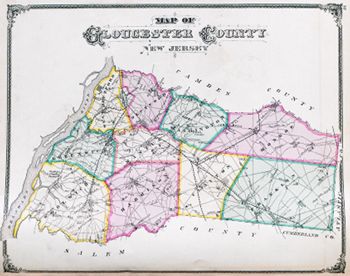
![Alexander C. Stansbie, James Keily, and Samuel M. Rea. "A Map of the Counties of Salem and Gloucester New Jersey. From Original Surveys" (Philadelphia: Smith & Wistar, 1849) [Library of Congress]. Wall map, with ornamental border and added color, 94 × 133 cm. Scale: approx. 0.8 mile to 1 inch.](https://libimages.princeton.edu/loris2/exhibits%2Fnj-historic-maps%2Fgloucester%2F1849-gloucester-county-wall-map.jp2/full/!750,750/0/default.jpg)
First wall map of Gloucester County. A yellow line marks its border with Salem County, much of which follows Old Man's Creek (called Oldmans Creek today). One of the two original counties of West Jersey, Gloucester's former territory had given birth to both Atlantic (1837) and Camden (1844) Counties. Here, the remnant consists of five townships (Deptford, Franklin, Greenwich, Harrison, Woolwich) colored in green, yellow, blue, or pink—with the Delaware River forming the northern boundary. A statistical table at the top, using 1847 data, provides the size (in acres), number of taxables and householders, and total paid county and state taxes for each township. (Each township averages only about five hundred landowners.) The "unscrolled" descriptive text on the map's right side notes Woodbury's important role in supplying the Philadelphia market with garden vegetables and firewood. An engraving presents a view of Woodbury from across the Woodbury Creek.
1834: Woodbury, p-t., and seat of justice of Gloucester co., on Woodbury creek, at the head of navigation, 8 miles S. of Camden, 39 from Trenton, and 145 from W.C.; contains a spacious court-house of brick, and county offices, fire-proof, and of the same material, detached, and a prison, in the rear of the court-house, of stone; 1 Friends' meeting house, large, and of brick; 1 Presbyterian church, frame, with cupola and bell, the upper part of which is used as an academy; and 1 brick Methodist church; 2 common schools; 2 public libraries, one of which was founded by the ladies of the town; 2 sunday schools; a county bible society; and temperance society, which has been productive of very beneficial effects; several store-keepers refusing to sell spirituous liquors; 10 stores, 3 taverns, 4 lawyers, 3 physicians, 1 clergyman, 100 dwelling houses, and 735 inhabitants. The town, for a mile in length, and half a mile in breadth, is incorporated, for the maintenance of a fire engine and fire apparatus, for which eight wells have been sunk; and the provisions for defence, against this devastating element, are very efficient. The creek was, 70 years since, stopped up; but the obstruction was removed in 1830, much to the convenience and health of the inhabitants. Vessels now load at the landing, in the town [Gordon, pp. 265–266].
Bold letters name the counties, villages, and towns, as well as the major roads. See, for example, the "Commissioners Road" (today's County Route 581), which prominently bisects Harrison Township, running from Mullica Hill south into Salem County. Some distances along them are given. Much of Deptford Township is shown covered with forest; half of Franklin Township is Pine Barrens (note the difference in the symbols used). Near Bridgeport (Woolwich Township) there is a cranberry marsh and a wooden causeway over wetlands. In the Delaware River by Tonkins Island (Woolwich Township), the side paddlewheel steamer Kent plies upriver. Built in Philadelphia in 1845, the steamboat serviced the Smyrna (Delaware) to Philadelphia route.
1876: County Atlas
![Everts & Stewart. Combination Atlas Map of Salem & Gloucester Counties, New Jersey:Compiled, Drawn and Published from Personal Examinations and Surveys (Philadelphia: Everts & Stewart, 1876) [courtesy of Joseph J. Felcone]. 86 pp., including maps. No scales given.](https://libimages.princeton.edu/loris2/exhibits%2Fnj-historic-maps%2Fgloucester%2F1876-gloucester-county-title-page.jp2/full/!320,320/0/default.jpg)
First atlas of Gloucester County. The atlas consists of a map of the United States and one of New Jersey, portraits and engravings, township histories, lists of county offices/officeholders, and a patrons' directory. The Gloucester section contains ten township maps, nineteen town/village maps, and fourteen lithographic views. (The Salem section of the atlas is described under Salem County.)
The number of townships has doubled to ten, colored in pink, green, orange (appears gray), or yellow: Clayton, Deptford, East Deptford, Franklin, Greenwich, Harrison, Mantua, Monroe, Washington, and Woolwich. The other most notable change since 1849 is the extension of railroad lines—some are just proposed—to the county's major towns.
◊ ◊ ◊

The circular grounds of the Pitman Grove Camp Meeting are shown at the bottom of the map: the tabernacle at the center and twelve "avenues" (only eight are shown), representing the twelve disciples, issuing out like spokes of a wheel. Named for Reverend Charles Pitman (1796–1854), the camp was founded in 1871 as a place for Methodist ministers and their families to meet in the summer. Eventually, small cottages were built. The district was added to the National Register of Historic Places in 1977. The town is still "dry": no liquor stores, no liquor licenses.
◊ ◊ ◊
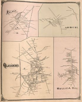
Glass manufacturing facilities are evident in Glassboro and Malaga.
1834: Glassboro', p-t. of Franklin township [part of Clayton Township in 1858], . . . contains an Episcopal and Methodist church, 2 glass houses or factories which make hollow ware, belonging to Messrs. Stanger & Co., 1 tavern, 2 stores, and about 30 dwellings [Gordon, p. 146].
In 1779, the skilled German glassblower Solomon Stanger and his family established a "glass works in the woods" here, where they found a good quality of sand (necessary for glass), abundant fuel (oak trees) to heat the furnaces, and proximity to Philadelphia, their primary market. Equidistant between New York City and Washington, D.C., Glassboro was chosen as a compromise site for a summit conference between President Lyndon B. Johnson and Soviet Premier Alexei Kosygin in June 1967. The talks took place at Glassboro State College, now Rowan University.
1834: Malaga, p-t. of Franklin t-ship . . . on the head waters of Maurice river . . . contains 1 tavern, 2 stores, a glass manufactory, employed on window glass, 30 dwellings and a grist mill [Gordon, p. 171].
Malaga is uniquely situated near where Gloucester, Cumberland, and Salem Counties meet.
1834: Mullica Hill, p-t. and village of Gloucester co. . . . on Raccoon creek . . . contains a Friends' meeting house, an Episcopal church, 2 taverns, 2 stores, and between 50 and 60 dwellings. The country around the village is much improved by the use of marl which abounds here, and in some places is found in an indurated state, assuming the character of limestone [Gordon, p. 188].
In 1991, Mullica Hill was added to the National Register of Historic Places as the Mullica Hill Historic District.
Back to Top