
New Jersey Counties: First Wall Maps and Atlases
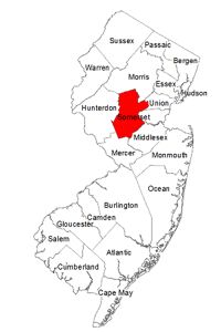
Somerset County
| County Data | |
| Founded: 1688, from Middlesex County |
|
| Total Area: 305 square miles | |
| Population: 22,057 (1860); 323,444 (2010) | |
| County Seat: Somerville | |
| Largest City: Franklin Township |
1850: County Wall Map
![J. W. Otley, L. Van Derveer, and J. Keily. "Map of Somerset County New Jersey Entirely from Original Surveys" (Camden, N.J.: Lloyd Van Derveer, 1850) [Library of Congress]. Wall map, with ornamental border and added color,104 × 85 cm. Scale: 1 mile to 1.5 inches.](https://libimages.princeton.edu/loris2/exhibits%2Fnj-historic-maps%2Fsomerset%2F1850-somerset-county-wall-map.jp2/full/!750,750/0/default.jpg)
First wall map of Somerset County. It includes a separate detailed plan of Somerville (at a scale of 33 perches to 1 inch). Engravings of the state capitol (Trenton), county buildings (Somerville), Young Ladies Institute (Somerville), A. Cammann residence (Somerville), First Dutch Reformed Church (Somerville), Brearley & Mount's Mills (Rocky Hill), and J. V. D. Kelly's mill property (Raritan) circle the map (clockwise from top left).
Eight townships, shown populated with landowners, are marked in pink, blue, orange, yellow, or green: Bedminster, Bernards, Branchburg, Bridgewater, Franklin, Hillsborough, Montgomery, and Warren. Major communities are named with bold capital letters. Some major township roads are identified—"Honeman's Lane" (Bedminster), also known as Honeyman's Lane, "Lime Kilns" (Bernards), "Amwell Road" (Hillsborough), and "Burnt Hill Road" (Montgomery)—which continue to this day. The Raritan River divides the county from west to east, and the Delaware and Raritan Canal follows the Millstone River along the western boundary of Franklin Township.
Abbreviations indicate the locations of schoolhouses, sawmills, gristmills, churches (Presbyterian, Dutch Reformed, Baptist, Methodist, Friends Meeting Houses), blacksmith and wheelwright shops, and post offices. The statistical table on the right side of the map gives the area (in acres and square miles) of each township, but the columns for taxable inhabitants and total population are empty. The "scrolled" description at the upper left boasts that the county "stands high for the general intelligence and high moral tone of its citizens and their attention to the cause of Education. Some of the greatest men whose names adorn the history of this state, claim it as their birth-place. It was the Camp ground of the Revolution."
The Sourland Mountain (Hillsborough Township) is the only major topographical feature of the county that is emphasized in large bold letters. The seventeen-mile ridge, stretching from Lambertville on the Delaware River to Neshanic in Somerset County, now comprises the largest contiguous forest in central New Jersey, and is an important rest stop for migratory birds. The "Fort Haunts [Fort Hans] and Roaring Rocks" label on that mountain area refers to (1) a rock shelter named for a Neshanic farmer and American Revolutionary pacifist named Hans van Pelt, and (2) the unique field of boulders under which the Roaring Brook flows, often creating a spectacular, roaring sound. Also located on the mountain are several earthenware manufacturers.
1857: Town Wall Map
![1857: Town Wall Map. Thomas Hughes. "Map of Somerville, the Seat of Justice of Somerset County, N.J." (Philadelphia: Lith. of Friend & Aub . . ., 1857) [Historic Maps Collection]. Wall map, with added color, 128 × 100 cm. "Population about 2200." Scale: 200 feet to 1 inch. One of five known institutional copies.](https://libimages.princeton.edu/loris2/exhibits%2Fnj-historic-maps%2Fsomerset%2F1857-somerville-wall-map.jp2/full/!350,350/0/default.jpg)
First wall map of Somerville. It is roughly oriented west (top) to east (bottom). Two dozen views of private residences and businesses, including two public educational facilities, surround the layout of the town's streets.
A list (left center) provides the addresses and occupations of the fifty-seven subscribers. Places marked "Lottery Field," on both sides of High Street near the public school, are remnants of a lottery held in 1809 by John Davenport, who disposed of his Main Street property by selling lottery tickets. Historically, these areas were occupied by African Americans. Note the "colored school" in the field.
1860: Township Wall Map
![1860: Township Wall Map. Matthew Hughes. 'Farm Map of Hillsboro', Somerset Co. N.J.' (Philadelphia: Printed by T. S. Wagner, 38 Hudson St., 1860) [Historic Maps Collection]. Wall map, with added color, 96 × 142 cm. Scale: 1 mile to 4.75 inches. One of two known institutional copies.](https://libimages.princeton.edu/loris2/exhibits%2Fnj-historic-maps%2Fsomerset%2F1860-hillsboro-farm-wall-map.jp2/full/!350,350/0/default.jpg)
First wall map of Hillsborough Township. The list of subscribers totals 137; 15 of them paid extra to have engravings of their farms, residences, or businesses adorn the sides of the map. This map and the one of Greenwich Township (Warren County) best exhibit the rich and proud farming lifestyle of nineteenth-century New Jersey.
1834: Hillsborough t-ship, Somerset co., . . . area, about 36,000 acres, surface on the west hilly, the Neshanic or Rock mountain extending over it; the soil clay and loam: on the east level and gently undulating; soil red shale. The whole t-ship is well cultivated. . . . Population in 1830, 2878. In 1832 the t-ship contained about 560 taxables, 95 householders, whose ratables did not exceed $30 in value, 58 single men, 9 stores, 8 saw mills, 8 grist mills, 1 fulling mill, 10 tan vats, 4 distilleries, 2 carding machines, 939 horses and mules, and 1638 neat cattle, of 3 years old and upwards; and paid state tax, $382.92; county, $1182.53. There is a Dutch Reformed church in the t-ship [Gordon, pp. 157–158].
1873: County Atlas
![Title page. F. W. Beers. Atlas of Somerset Co., New Jersey: From Recent and Actual Surveys and Records (New York: Beers, Comstock & Cline, 1873) [Historic Maps Collection]. 62 pp., including maps.](https://libimages.princeton.edu/loris2/exhibits%2Fnj-historic-maps%2Fsomerset%2F1873-title-page.jp2/full/!320,320/0/default.jpg)
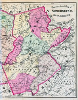
First atlas of Somerset County. Another slim volume, the atlas contains a map of the United States, a map of New Jersey, a map of the combined counties of Somerset and Hunterdon, nine township maps, twenty-one maps of towns and villages, a table of distances, and tables of the state's 1870 census figures. Many of the maps contain "Business Notices" that name merchants, businesses, and services.
Pink, green, orange, and yellow colors distinguish between the nine townships: Bedminster, Bernard, Branchburg, Bridgewater, Franklin, Hillsborough, Montgomery, North Plainfield, and Warren. The Delaware and Raritan Canal parallels the Millstone River, and a number of railroads run east–west across the county.
At the bottom of the map, between Rocky Hill and Kingston is the label "Washington's Headquarters 1777." The date should be 1783, when the Continental Congress temporarily removed to Princeton to escape the anger of unpaid troops in Philadelphia. At that time, General George Washington was in Newburgh, New York, with the remains of his standing army when he was called to appear before Congress. A suitable residence was found for him and his entourage in nearby Rocky Hill, a widow's estate called "Rockingham" that was being put up for sale.
◊ ◊ ◊
!["Bedminster [Township]." Lithograph map, with added color, 34.4 × 28.1 cm. Scale: 200 rods to 1 inch.](https://libimages.princeton.edu/loris2/exhibits%2Fnj-historic-maps%2Fsomerset%2F1873-bedminster-township-map.jp2/full/!750,750/0/default.jpg)
The proposed route of the New Jersey West Line Railroad dissects the bottom of the township. But, due to competition and wrangling among bondholders, only the section between Bernardsville (Somerset County) and Summit (Union County) was ever completed. Numbers along the roads indicate approximate distances (in rods).
◊ ◊ ◊
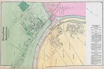
The map shows Bound Brook in green, Bloomington in yellow. Bloomington became South Bound Brook in 1891. Lumber manufacturers and dealers dominate the "Business Notices." The Codington & Tappen Co. (Coddington & Tappan) lumberyard occupied a large part of Bloomington at the time, but the partners dissolved their business in 1875 (two years after this map). The Queen's Bridge, across which Hessian troops pursued American patriots in the Battle of Bound Brook during the American Revolution, is the green/yellow line across the Raritan River
The three other proposed bridges across the Raritan River never developed, but today Interstate 287 crosses into South Bound Book farther to the west, cuts across the bend in the river, and then crosses it again to the east.