
New Jersey Counties: First Wall Maps and Atlases
Mercer County
| County Data | |
| Founded: 1838, from parts of Hunterdon, Middlesex, and Burlington Counties |

|
| Total Area: 229 square miles | |
| Population: 37,419 (1860); 366,513 (2010) | |
| County Seat: Trenton | |
| Largest City: Hamilton Township |
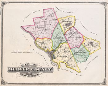
1849: County Wall Map
![J. W. Otley and J. Keily. "Map of Mercer County, New Jersey Entirely from Original Surveys" (Camden, N.J.: L. van der Veer, 1849) [Historic Maps Collection]. Wall map, with ornamental border and added color, 78 × 99 cm. Scale: 1 mile to 1.5 inches.](https://libimages.princeton.edu/loris2/exhibits%2Fnj-historic-maps%2Fmercer%2Fwallmap-mercer-county-1849.jp2/full/!750,750/0/default.jpg)
First wall map of Mercer County. It includes inset maps of Trenton and Princeton Borough. Green, yellow, pink, blue, and orange colors distinguish the eight townships—East Windsor, Ewing, Hamilton, Hopewell, Lawrence, Nottingham, Princeton, West Windsor—and the incorporated city of Trenton. (Absorbed by the city, the township of Trenton was dissolved in 1837.) Engravings of the Lawrenceville High School (today's private school) and Princeton College (Princeton University), as well as the "State Lunatic Asylum" and state capitol, grace the top and sides of the map. "Pleasant Valley" labels a central fertile region of Hopewell Township; dual town names in Hamilton Township, such as "Mercerville or Sandtown" and "Yardville or Sand Hills," suggest a less productive topography. Longitude is measured east from Washington, D.C.

A key provides abbreviations for locating schoolhouses, sawmills, gristmills, churches, and the shops of blacksmiths and wheelwrights. A statistical table gives the area of each municipality in both square miles and acres. Unfurling as if written on a scroll, the descriptive text notes the richness of the area's soil and the national importance of its two flourishing "literary" institutions—and boasts that "Two battles (memorable for turning the tide of the American Revolution) were fought within these limits." The references are to the Battle of Trenton (December 26, 1776) and the Battle of Princeton (January 3, 1777). To surprise the British at Trenton, General George Washington and his army crossed the Delaware River from Pennsylvania during the night of December 25, 1776, near where the bridge joining Taylor's Ville, Pennsylvania, with Bernardville, New Jersey, is shown on the map. Washington's victory in the battle was a turning point in the American Revolution.
The location of the Battle of Princeton is shown on the map near where the Princeton Turnpike enters the pink of Princeton Township.
All town and village names appear in bold capital letters on the map. Though shrunken in territory, Nottingham Township, shown in orange below Trenton, was one of the initial set of townships created by the state in 1798. In ensuing years, however, parts of it were annexed by neighboring townships, and Hamilton Township was created from other portions of it in 1842. Finally, in 1856, the township was dissolved, with the remaining area divided between the city of Trenton and Hamilton Township. The Straight Turnpike, seen running diagonally northeast across the center of the map from Trenton, is today's Route 1. Almost perfectly straight, it was constructed with drainage ditches and wooden bridges by the Trenton and New Brunswick Straight Turnpike Company (1804–1806). (See its continuation to New Brunswick in the Middlesex County map.) As a primary conduit between the cities of New York and Philadelphia, it became the nation's busiest road during its early history.
The Trenton Water Power Canal features prominently in the detailed map of Trenton at the lower left. The project of the Trenton Delaware Falls Company, the seven-mile canal was finished in 1834, fueling industrial development by providing power to mills along its length. Its greatest engineering achievement was a masonry and timber aqueduct over the Assunpink Creek.

1868: Bridge over Assunpink Creek at Trenton, N.J. This spot is one of much historic interest. Here it was, in all probability, that the fate of the American Revolution was decided. Had the British troops effected their passage across the bridge then standing on this spot it seems hardly possible that Washington could have effected the masterly movement to Princeton which saved his army.1
This is a reference to events during the Second Battle of Trenton, which took place on January 2, 1777, a week after Washington's successful surprise attack on the sleeping Hessians. During this second battle, three different British assaults on the Assunpink bridge were repulsed by American fire, delaying the major engagement. Washington was able to withdraw his forces under cover of night and met the British in Princeton the next day.
1852: Borough Wall Map
![John Bevan. "Map of Princeton, Mercer County, New Jersey" (Jersey City, N.J.: John Bevan, 1852) [Historic Maps Collection]. Wall map, with ornamental border and added color, 37 × 72 cm, on sheet 75 × 95 cm. Scale: 400 feet to 1 inch. One of six known institutional copies.](https://libimages.princeton.edu/loris2/exhibits%2Fnj-historic-maps%2Fmercer%2F1852-princeton-wall-map.jp2/full/!350,350/0/default.jpg)
First wall map of Princeton Borough. The College of New Jersey (now Princeton University) occupies the center of the map. (The college was renamed at its sesquicentennial in 1896.) All six vignettes surrounding the map portray educational facilities: four of Princeton, one of the Edgehill Grammar School, and one of the Princeton Theological Seminary.
The subscribers' list on the right of the map provides a cross section of the community; it includes tradesmen (tailors, painters, booksellers/printers), professionals (professors, physicians, attorneys), local businesses (bank, tin ware, hotel, saddlery, dry goods), and students Among the latter are a significant number from South Carolina, Mississippi, Alabama, Louisiana, and Texas—presumably from wealthy Southern families who regarded Princeton, New Jersey, as an amenable environment before the Civil War. The subscribers are keyed to the map, but it is unclear what the categories of subscription were.
1834: Princeton, p-t. and borough, partly in Montgomery t-ship, Middlesex co., on the main road between New York and Philadelphia, . . . situated in a very pleasant country of red shale and alluvion, and remarkable for the salubrity of its climate, the beauty of its villas, and the neatness, generally, of its buildings. It was incorporated as a borough in 1813, and contains about 185 dwelling houses, and at least 1100 inhabitants, exclusive of the youth connected with the public institutions, of whom there are, at present (1833), about 350. The Delaware and Raritan canal runs within a half mile of the borough, and has already contributed, in no small degree, to its prosperity. The office of the company is established here. Besides the buildings belonging to the literary institutions, there are in Princeton, a Presbyterian church, and Episcopal church, and two other houses for public worship, belonging to the Presbyterian society; one of which is for the use of the coloured population. The literary institutions of Princeton are a college, a theological seminary, three classical schools, two schools for the instruction of young ladies, and three or four common schools; all independent of each other [Gordon, p. 221].
1874: City Bird's-Eye View
![Fowler & Bailey. "Trenton, New Jersey" (Philadelphia: H. J. Toudy & Co., 1874) [Historic Maps Collection]. Lithograph view, 58 × 81 cm. Scale: none given.](https://libimages.princeton.edu/loris2/exhibits%2Fnj-historic-maps%2Fmercer%2F1874-trenton-wall-map.jp2/full/!350,350/0/default.jpg)
First panoramic map of Trenton. Thaddeus Mortimer Fowler (1842–1922) was probably the most prolific maker of bird's-eye views of American cities, with more than four hundred to his credit, covering twenty-one states and three Canadian provinces. Fowler lived in Trenton for part of his life and is buried in its Riverview Cemetery. The heyday of this map form was the post–Civil War era, up to the early twentieth century. Viewed from above at an oblique angle, the areas shown in these maps are not drawn to scale—rather, the maps emphasize street patterns, some individual buildings, and/or special landscape features. To accomplish the unique rendering, the artist first prepared a general frame of reference, possibly, in this case, drawing from the Trenton map in F. W. Beers's 1872 state atlas. He then would spend a considerable amount of time researching and walking the streets to render details accurately. These would be transferred, via the drafting technique of isometric projection, to the frame. Sometimes features were idealized to help local chambers of commerce portray their communities in an attractive and vibrant manner. These independently published maps were popular wall ornaments during the Victorian Age.
The key to this Trenton map locates many businesses, churches, and public buildings. Among them are two flour mills, three pottery manufacturing companies, six planing mills, and twenty-two religious institutions. "Dolton's Block," the featured image at the bottom center, is number 10: William Dolton & Co., Wholesale Grocers. (Bordered by Warren and West Hanover Streets, the block is now a parking garage.) On the far right, fronting Second Street, are the various wings of the Trenton State Prison (marked #4). The original prison on the site, the New Jersey Penitentiary House, built in 1798, was the first New Jersey state prison and the third in the nation. Only the Front House of that facility remains, shown as the street's penultimate structure at the edge of the map; it is designated as a residence for the Keeper of the State Prison.
Engraved over the front door are these words:
LABOUR, SILENCE, PENITENCE.
The Penitentiary House
Erected by LEGISLATIVE Authority
RICHARD HOWELL, Governor
In the XXII Year of Amern Independence
MDCCXCVII
That those who are feared for their Crimes
May learn to fear the Laws and be useful
Hic labor hoc opus!
The shortened quote from Virgil's Aeneid—"Hoc opus, hic labor est" (This is the task and the labor)—probably reflects the practical Quaker workhouse sentiment of the time, acknowledging the difficult "climb" reformed criminals must make from their "descent" into sin. ("There's the rub.")
The building at "Five Points" (the intersection of Warren and Greene Streets with Brunswick, Princeton, and Pennington Avenues), in the left center of the map, has been replaced with a spectacular 150-foot granite column.

1875: County Atlas
![Everts & Stewart. Combination Atlas Map of Mercer County, New Jersey (Philadelphia: Everts & Stewart, 1875) [Historic Maps Collection]. 46 pp., including maps.](https://libimages.princeton.edu/loris2/exhibits%2Fnj-historic-maps%2Fmercer%2F1875-titlepage.jp2/full/!320,320/0/default.jpg)
First atlas of Mercer County. The volume contains maps of the United States, New Jersey, and Mercer County, eight township maps, fourteen other town or village maps, and eight pages devoted to the mapping of the wards of the City of Trenton. Also, there are forty lithographic views of public buildings, businesses, and private residences, as well as portraits of four prominent citizens. Prefatory material includes a chronological list of the governors of New Jersey (from 1738 to 1875); lists of post offices and Mercer County and Trenton officials; histories of Mercer County, Trenton, and each township; and personal sketches of prominent men. In the back is "Business Directories of the Cities and Villages of Mercer County, Giving Names [with nativity and date of settlement], Locations, and Explicit Directions of Business of Our Patrons." The last page contains advertisements for four Trenton businesses. Unusual for county atlases is the "References" section on the table of contents page, which exhibits fifteen symbols that are utilized on the maps to locate such features as farmhouses, mills, stone quarries, orchards, and timber areas.
The eight townships are colored pink, green, or yellow: East Windsor, Ewing, Hamilton, Hopewell, Lawrence, Princeton, Washington, and West Windsor. The municipalities of Princeton, Hightstown, and Trenton are singled out in gray. Adjacent areas to Trenton labeled "Chambersburg" and "Millham" appear similarly shaded. Chambersburg became an incorporated municipality in 1872 from portions of Hamilton Township; in 1888, it became a neighborhood in Trenton. In 1882, Millham was incorporated as a township from part of Lawrence Township but was annexed by Trenton six years later.
◊ ◊ ◊
The map shows no major center or "downtown" area in the township; rather, there are clusters of settlements, most notably in the Mercerville–Hamilton Square and Yardville–Groveville regions. The Delaware River to the west, Crosswicks Creek to the south, and Assunpink Creek on the north provide natural boundaries. Numerous landowners are named and located—beside their names are numbers indicating the size (in acres) of their farms.
◊ ◊ ◊
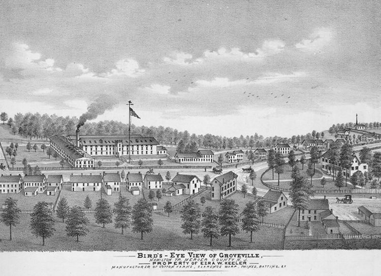
1834: Groveville, village of Nottingham t-ship, Burlington co., in a bend of the Crosswick's creek, . . . contains a large woolen manufactory, a grist and saw mill, and 10 or 12 houses. The creek is navigable from the Delaware to the village, a distance of more than six miles [Gordon, p. 153].
◊ ◊ ◊
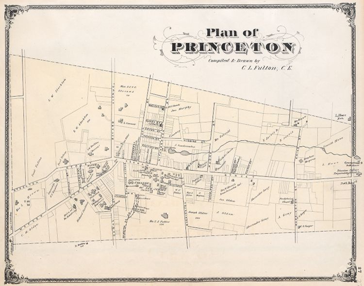
Perhaps the biggest changes since 1852 (date of the wall map) are evident in the area around the university. College Avenue is gone; Nassau Street has narrowed, eliminating the market; Railroad Avenue (today's University Place) has appeared, leading to the terminus of a railroad branch that still runs from Princeton Junction to the campus. (It is the shortest scheduled commuter rail line in the United States.) Opened in 1865, the station of the "Dinky," as the train is affectionately known, has been drifting south as the campus has expanded.
