New Jersey Counties: First Wall Maps and Atlases
Hunterdon County
| County Data | |
| Founded: 1714, from northern part of West Jersey, including part of Burlington County |

|
| Total Area: 437 square miles | |
| Population: 33,654 (1860); 128,349 (2010) | |
| County Seat: Flemington | |
| Largest City: Raritan Township |
1851: County Wall Map
![Samuel C. Cornell. "Map of Hunterdon County, New Jersey: Entirely from Original Surveys" ([Philadelphia]: Van Derveer & Cornell, 1851) [Library of Congress]. Wall map, with ornamental border and some added color, 123 × 92 cm. Scale: 1 mile to 1.5 inches.](https://libimages.princeton.edu/loris2/exhibits%2Fnj-historic-maps%2Fhunterdon%2F1851-hunterdon-county-wall-map.jp2/full/!750,750/0/default.jpg)
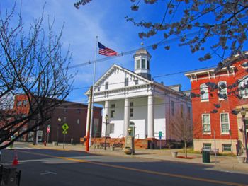
First wall map of Hunterdon County. The names of the twelve townships are displayed in large bold letters, spaced out across their territories: Alexandria, Bethlehem, Clinton, Delaware, East Amwell, Franklin, Kingwood, Lebanon, Raritan, Readington, Tewksbury, and West Amwell. ("Lambert Ville" incorporated as a town in 1849 from portions of West Amwell Township.) The names of towns and villages are printed in smaller bold capitals. The promotional text panel on the left touts the iron ore and limestone–rich hilly/mountainous regions of the county's north and the abundance of water power (from numerous streams and rivers) which makes manufacturing possible. "Situated within convenient reach of two of the greatest Cities and best markets in the Union and having cheap and easy communications with them, this County may be considered one of the finest and most opulent of the State." Only two illustrations of public buildings adorn the map: the state capitol in Trenton and the county's municipal building in Flemington.
In addition to the county map, there are also plans of the county's two largest towns, Flemington (no scale) and Lambertville (10 perches to 1 inch). In the latter, the route of the feeder canal for the Delaware and Raritan Canal is visible. Changes were made so that vessels from Pennsylvania's Delaware Division Canal could come over and lock into the canal here. The map's key references schoolhouses, churches (by denomination), and types of shops (blacksmith, wheelwright, shoemaker, cooper).
The dotted line shown crossing the Delaware River into Lambertville, then following the York Road in a northeasterly direction through West and East Amwell townships, across the Raritan River, to Centreville and beyond, is a section of the first commercial telegraph line, connecting Washington, D.C., to New York City, completed by the Magnetic Telegraph Company in 1846. The Somerville and Easton Turnpike, running through Bethlehem, Clinton, and Tewksbury Townships, was one of the state's major thoroughfares in its day, with taverns stationed approximately every mile. This is Route 22 today, a large portion of which coincides with Interstate 78.
1873: County Atlas
![F. W. Beers. Atlas of Hunterdon County, New Jersey: From Recent and Actual Surveys and Records (New York: Beers, Comstock & Cline, 1873) [Historic Maps Collection]. 77 pp., including maps.](https://libimages.princeton.edu/loris2/exhibits%2Fnj-historic-maps%2Fhunterdon%2F1873-titlepage.jp2/full/!320,320/0/default.jpg)
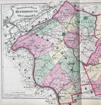
First atlas of Hunterdon County. A slim volume, the atlas contains maps of the United States, the state of New Jersey, and the combined counties of Hunterdon and Somerset, fourteen township maps, and maps of thirty-two towns and villages (Flemington's is a large foldout). It contains a chart of distances between county jurisdictions and census figures for the state from the 1870 census, arranged alphabetically by county.
The townships (now fourteen in number) are colored pink, green, orange (appears gray), or yellow: Alexandria, Bethlehem, Clinton, Delaware, East Amwell, Franklin, High Bridge, Kingwood, Lebanon, Raritan, Readington, Tewksbury, Union, and West Amwell. The municipalities of Lambertville (1849), Frenchtown (1867), Clinton (1865), and Fairmont (Fairmount) are darker green patches. (In 1996, seventy-two buildings in the Fairmount area were registered on the National Register of Historic Places as a historic district. There is no Fairmount town.) Several railroads already traverse the county, and the proposed route for a new one across Alexandria, Union, and Franklin Townships is shown.
◊ ◊ ◊
!["Raritan [Township]." Lithograph map, with added color, 28.5 × 35 cm. Scale: 200 rods to 1 inch.](https://libimages.princeton.edu/loris2/exhibits%2Fnj-historic-maps%2Fhunterdon%2F1873-raritan-township-map.jp2/full/!350,350/0/default.jpg)
Centered on Flemington, the township's school districts are colored yellow, pink, orange, or green, and the locations of the schools are given. Outside of the towns, landowner names are prominently displayed along the roads.
◊ ◊ ◊
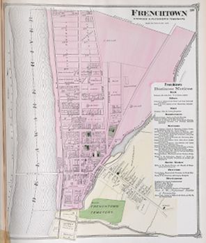
The town straddles two townships, Kingwood (pink) and Alexandria (yellow). The early presence of French-speaking settlers led some to call the place "Frenchtown," a name that ultimately was adopted.
1834: Alexandria, p-t. of Alexandria t-ship, Hunterdon co., on the Bank of the Delaware river, at the junction of Nischisakawick creek, . . . contains a tavern, store, grist mill, and 8 or 10 dwellings, a Presbyterian and an Episcopal church [Gordon, p. 93].
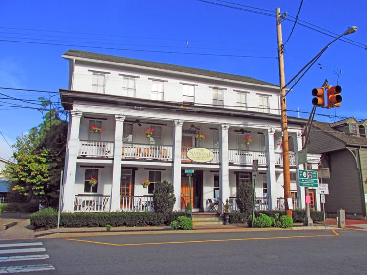
Running down the right side of the map is a panel of business notices: bank, editors, hotel (National), manufacturers, merchants, marble worker, physicians, and miscellaneous. The name of the "professional teacher of penmanship" is printed in an elegant italic font. On the map, the churches, public school, and cemetery stand out in dark green. Shown crossing the Delaware River is the original covered bridge, which opened in 1844.