
New Jersey Counties: First Wall Maps and Atlases
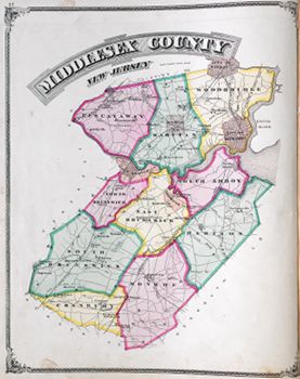
Middlesex County
| County Data | |
| Founded: 1683, one of the four original counties of East Jersey |

|
| Total Area: 323 square miles | |
| Population: 34,812 (1860); 809,858 (2010) | |
| County Seat: New Brunswick | |
| Largest City: Edison |
1850: County Wall Map
![J. W. Otley. "Map of Middlesex County, New Jersey Entirely from Original Surveys" (Camden, N.J.: L. Van Derveer, 1850) [Library of Congress]. Wall map, with ornamental border, 95 × 95 cm. Scale: 1 mile to 1.5 inches.](https://libimages.princeton.edu/loris2/exhibits%2Fnj-historic-maps%2Fmiddlesex%2F1850-middlesex-county-wall-map2.jp2/full/!750,750/0/default.jpg)
First wall map of Middlesex County. It includes detailed plans of New Brunswick and Perth Amboy. Centered at the top in the border is an engraving of Rutgers College (New Brunswick), and an engraving of the Middlesex County Courthouse (New Brunswick) hovers over the title.
While the top and bottom of the county are dense with landowners' names, the central and eastern portions are heavily wooded. The Raritan River divides the county and empties into Raritan Bay. (Its watershed drains much of central New Jersey.) The map key's abbreviations reference schoolhouses, saw and gristmills, different denominations of churches, blacksmith and wheelwright shops, and post offices. A statistical table lists the sizes (in acres and square miles) of the seven townships: Monroe, North Brunswick, Perth Amboy, Piscataway, South Amboy, South Brunswick, and Woodbridge. (Woodbridge was the first township in the state, chartered in 1669.) The capital letters of their names boldly claim their territories, which are marked by faint dotted lines.
Pigeon Swamp, seen just below the "-wick" letters of South Brunswick, is a state park today, as well as a National Natural Landmark. Several efforts to drain it to create farmland failed; the Great Ditch, shown next to it, was a very early effort, supported by the state legislature in 1780. The swamp was a major nesting site of the passenger pigeon before the species became extinct. The large open area labeled "Indian Fields," also in South Brunswick, was the site of a fairly large eighteenth-century Indian village. Running up and across from the lower left of the map, the Straight Turnpike (today's Route 1) finishes in New Brunswick.
In the New Brunswick map, Rutgers College (today's state university) occupies the block bordered by College Avenue, and Somerset, Hamilton, and George Streets. In the Perth Amboy map, the Inventor's Institute shown on Commerce Street, operating out of the former Royal Barracks built for British troops before the American Revolution—and the current location of the administrative offices of the Perth Amboy Board of Education—was established in 1847 by Dr. Solomon Andrews. This was the site of the launch on June 1, 1863, of the Aereon One dirigible, invented and piloted by Dr. Andrews. He offered the airship to Abraham Lincoln for use in the Civil War, but the government showed little interest in it.
1876: County Atlas
![Everts & Stewart. Combination Atlas Map of Middlesex County, New Jersey Compiled, Drawn and Published from Personal Examinations and Surveys (Philadelphia: Everts & Stewart, 1876) [Historic Maps Collection]. 82 pp., including illustrations and maps.](https://libimages.princeton.edu/loris2/exhibits%2Fnj-historic-maps%2Fmiddlesex%2F1876-titlepage.jp2/full/!320,320/0/default.jpg)
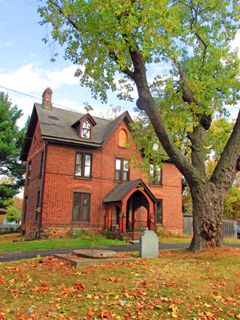
First atlas of Middlesex County. The volume contains maps of the United States, the state of New Jersey, Middlesex County, ten townships, nineteen towns/villages, and two cities (New Brunswick and Perth Amboy). Forty-two lithographic views of residences, farms, county offices, and businesses are also included. It begins with a history of the county and its townships and villages, including personal sketches of several prominent families, and ends with business directories, listing by township, then alphabetically, the subscribers. For each, the person's name, date of settlement in the county, nativity, post office address, and occupation are provided. Additionally, there are tables of county officials and governors.
As the map shows, there are now ten townships, colored in pink, green, or yellow: Cranbury, East Brunswick, Madison, Monroe, North Brunswick, Piscataway, Raritan, South Amboy, South Brunswick, and Woodbridge. Two cities (New Brunswick and Perth Amboy) and two boroughs (Washington, today's South River, and Metuchen) are in orange, though the latter appears gray. (Rahway, at the top right is part of Union County.) The Camden & Amboy Railroad and the Pennsylvania Railroad run parallel tracks through the county. Visible above Metuchen in Raritan Township is Menlo Park, an unsuccessful real estate development of the 1870s.
◊ ◊ ◊
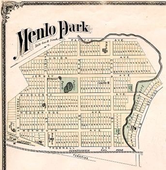
In late 1875, inventor Thomas Edison (1847–1931) purchased thirty-four acres here; the real estate office, seen at the corner of Christie Street and Thornall Avenue, became his home. His main laboratory was built up the hill, on the land between Middlesex and Woodbridge Streets, where a small lake is pictured. This Menlo Park facility was the nation's first industrial research laboratory, and quickly became an "invention factory." Approximately four hundred inventions were patented here, including the phonograph and the incandescent light bulb. Christie Street became the first in the world to be lit by electric lights. (Thornall Avenue is now Route 27, part of the Lincoln Highway; Woodbridge Avenue has become Tower Road.)
◊ ◊ ◊
!["Map of Cranbury Township." Lithograph map, with added color, 39.7 × 31 cm. Scale: [1 mile to 2 inches].](https://libimages.princeton.edu/loris2/exhibits%2Fnj-historic-maps%2Fmiddlesex%2F1876-cranbury-township-map.jp2/full/!350,350/0/default.jpg)
This was the county's last township to be organized (1872), from parts of South Brunswick and Monroe. The Millstone River forms its southern border; Cranbury Brook, a tributary, is its major waterway. Building symbols locate schoolhouses and churches. The entire downtown area of Cranbury has been designated as a historic district and was listed on the National Register of Historic Places in 1980.
◊ ◊ ◊

A schoolhouse and four church properties are colored green. With a line just six miles in length, the Perth Amboy and Woodbridge Railroad, shown bisecting the town, was operated by the Pennsylvania Railroad. Today, it is part of New Jersey Transit's North Coast Line. Jonathan Singletary Dunham (1640–1724), a prominent early settler, built the state's first gristmill here.
