
New Jersey Counties: First Wall Maps and Atlases
Morris County
| County Data | |
| Founded: 1739, from Hunterdon County |

|
| Total Area: 482 square miles | |
| Population: 34,677 (1860); 492,276 (2010) | |
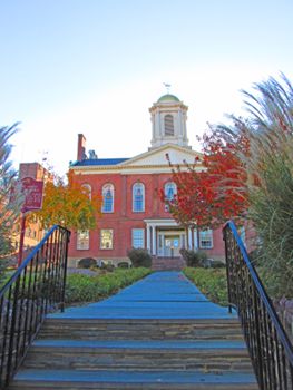
| County Seat: Morristown | |
| Largest City: Parsippany–Troy Hills |
1853: County Wall Map
![Jesse Lightfoot. "Map of Morris County, New Jersey, from Original Surveys" (Morristown, [N.J.]: J. B. Shields, 1853) [Historic Maps Collection]. Wall map, with ornamental border and added color, 127 × 92 cm. Scale: 1 mile to 1.5 inches.](https://libimages.princeton.edu/loris2/exhibits%2Fnj-historic-maps%2Fmorris%2F1853-morris-county-wall-map.jp2/full/!750,750/0/default.jpg)
First wall map of Morris County. It includes detailed plans of Dover and Morristown on the lower sides. Engravings of five Morristown buildings embellish the border: the courthouse, W. S. Cooper's Mansion House, the Second Presbyterian Church, the Episcopal Church, and the First Presbyterian Church.
The eleven townships are colored yellow, pink, orange, green, or blue: Chatham, Chester, Hanover, Jefferson, Mendham, Morris, Pequanack, Randolph, Rockaway, Roxbury, and Washington. Major communities are lettered in bold capitals, as are important geographical features, such as Schooley's Mountain and German Valley (Washington Township), Suckasunny Plains (Roxbury), Copperas Mountain (Rockaway), Lime Stone Quarry (Pequanack), Parsippany Woods and several meadows (Hanover), Great Swamp (Morris and Chatham), and Long Hill (Chester). Several thousand pre–Civil War landowners are named.
The Morris Canal snakes across the northern part of the county, using locks and innovative water-driven inclined planes to facilitate the movement of barges across the hilly areas. (Note the plane and lock numbers.) Also shown is its feeder canal from the state's largest body of freshwater, Lake Hopatcong (earlier known as Brookland), which borders Sussex and Morris Counties. The adjacent "Reservoir" (today's Lake Musconetcong) was created as an additional source of water for the canal.
1850: Town Wall Map
![Marcus Smith (1815-1904). "Map of Morristown, Morris County, N.J." (New York: Marcus Smith, 103 Fulton Street, 1850) [Historic Maps Collection]. Wall map, with ornamental border and added color, 91 × 69 cm. Scale: 300 feet to 1 inch. One of two known institutional copies.](https://libimages.princeton.edu/loris2/exhibits%2Fnj-historic-maps%2Fmorris%2F1850-morristown-map.jp2/full/!750,750/0/default.jpg)
First wall map of Morristown. It includes a detailed inset map (scale: 2 chains to 1 inch) of the town center around "The Park" and vignettes of eight buildings along the left top and bottom borders: the private residences of Steven (father) and George (son) Vail, developers of the Speadwell Iron Works; the courthouse; the 1st Presbyterian Church and its parsonage; the 2nd Presbyterian Church; and the Episcopal Church and its parsonage. Much of the area appears heavily wooded.
The Speedwell Iron Works, located where the Whippany River runs through a natural gorge into Speedwell Pond at the top of the map, produced agricultural and industrial machinery, including most of the components for the U.S.S. Savannah’s steam engine, which was the first to be installed on an ocean-going ship. Fort Nonsense on Mount Washington (bottom left) was originally built by order of General George Washington in 1777 during the American Revolutionary War. The strategic spot offered commanding views of lands to the north, east, and south. Prominently bisecting the map from the top to the center right, the Morris & Essex Railroad, started in Newark (Essex County) in 1835, stretched to Morristown (Morris County) in 1838, and, continuing west, reached its ultimate destination, Phillipsburg (Warren County), on the Delaware River in 1866. A competitor to the Morris Canal (and one cause for its demise), the railroad offered a more efficient alternative for transporting goods across the northern part of the state.
1874: Town Wall Map
![George L. Hull. "Map of Morristown, Morris County, N.J." ([Morristown, N.J.?]: Geo. L. Hull, 1874) [Historic Maps Collection]. Wall map, with added color, segmented in twenty-four pieces, mounted on cloth, 170 × 126 cm. Scale: 200 feet to 1 inch. One of five known institutional copies.](https://libimages.princeton.edu/loris2/exhibits%2Fnj-historic-maps%2Fmorris%2F1874-morristown-map.jp2/full/!750,750/0/default.jpg)
Second wall map of Morristown. Among its numerous details, the map contains two important historic sites: one military, the other scientific.
Shown on the map near the juncture of Morris Street and Washington Avenue (see "Henry W. Ford") is the headquarters used by General George Washington during the severe winter of 1779–1780, when his troops camped in nearby Jockey Hollow, outside of town. Colonel Ford had participated in the Battle of Princeton, but he died in this house from pneumonia about a week later. Washington rented part of it from Ford's widow. The house is now owned by the National Park Service as part of the Morristown National Historic Park.
This is the birthplace of the telegraph. Though Samuel F. B. Morse is credited as the father of the American telegraph, he would not have succeeded without his Morristown partner, Alfred Vail. Their formal agreement was signed on September 23, 1837, giving Vail one-fourth of all American rights upon construction, at his cost, of a workable model that could be exhibited to officials in Washington, D.C. It was Vail who developed the powerful electromagnets that the system required. The first successful public demonstration of the telegraph took place at Vail's estate (Speedwell Iron Works) on January 11, 1838. The transmitted message, "Railroad cars just arrived, 345 passengers," emphasized the future practical and commercial uses of the invention. The telegraph demonstration took place in this building, called the Factory. Restored in 2008, it is a National Historic Landmark.
1868: County Atlas
![F. W. Beers. Atlas of Morris Co., New Jersey from Actual Surveys (New York: Beers, Ellis & Soule, 1868) [Historic Maps Collection]. 30 leaves, including illustrations and maps.](https://libimages.princeton.edu/loris2/exhibits%2Fnj-historic-maps%2Fmorris%2F1868-title-page.jp2/full/!320,320/0/default.jpg)

First atlas of Morris County. The volume begins with a table of county distances and a county map. Maps of fourteen townships and twenty-seven towns and villages follow, including a large foldout plan of Morristown. There are also six views: First and Second Presbyterian Churches (Morristown), Schooley's Mountain Seminary (Washington Township), Methodist Episcopal Church (Boonton), Washington's Headquarters (Morristown), and Boonton Academy (Boonton).
Now grown to fourteen, the townships are differentiated in pink, green, yellow, or orange: Boonton, Chatham, Chester, Hanover, Jefferson, Mendham, Montville, Morris, Passaic, Pequannock, Randolph, Rockaway, Roxbury, and Washington. The municipalities of Boonton (1867) and Morristown (1865) are green. Much of the county appears well-developed with roads; the major other transportation arteries are the Morris Canal and the Morris and Essex Railroad.
◊ ◊ ◊
!["Washington [Township]." Lithograph map, with added color, 26.4 × 34.3 cm. Scale: 1 mile to 1.5 inches.](https://libimages.princeton.edu/loris2/exhibits%2Fnj-historic-maps%2Fmorris%2F1868-washington-township-map.jp2/full/!350,350/0/default.jpg)
The township is divided into fourteen school districts, tinted in yellow, green, pink, or orange. The faint numbers along the roads show the distances in rods between junctions, and a township directory provides the names and occupations of prominent professionals, tradesmen, and farmers.
1834: Schooley's Mountain, Schugl's Hills, forms part of the central granitic chain. . . . The mineral spring near the top has given much celebrity to this region. . . . Remarkable cures have been ascribed to it. . . . To those in pursuit of health or pleasure, this region presents equal attraction. A short journey brings the patient from the level of the tide water to a very desirable elevation, which tempers the summer's heat, and braces the relaxed frame. The plain on the top of the mountain affords very pleasant rides amid ever changing and delightful scenery, in which cheering views of improved and profitable agriculture are blended with the velvet plain, the craggy hill, and shadowy vale. Thus the invalid has every incentive to exercise, by the highest gratification from his exertions. To him who seeks relaxation from the cares of business, or to change sedentary occupation and feebleness for activity and vigour, the excellent society which assembles here during the summer months, the abundant sport in fowling and fishing, and the delightful scenery hold forth strong inducements; to which, we would be unjust not to add the excellent fare, cheerful attention, and comfortable accommodation given to visitors at the three hotels, and several farm houses in the vicinity of the spring [Gordon, pp. 233–235].

◊ ◊ ◊

The town is situated at the nexus of the Morris Canal, the Rockaway River, and the Morris and Essex Railroad. Its growth in the fifteen years since the county wall map (see the Dover insert on it for comparison) is apparent everywhere, but particularly in the downtown area: Morris Street has replaced the old Essex Street; a new Essex has replaced the old Bergen; a new Bergen has emerged further to the right. A second bridge now crosses the Rockaway River. The extensive business directory, covering Randolph Township as well as Dover, includes a number of iron mine agents. Church and private educational properties are colored green.
Back to Top1834: Dover, p-t. of Randolph t-ship, Morris co., on the Rockaway river, 8 miles N.W. from Morristown, 233 N.E. from W.C, and 67 from Trenton; the mountains recede here, and form a small plain, on which the town is built, on several streets and on both sides of the river, which is passed by one, perhaps more bridges. It contains 3 rolling and slitting mills, boring and turning engines, a cupola furnace or foundery, and saw mill, the property of the heirs of the late Mr. McFarlane, of New York, a factory of machinery, owned by W. Ford, a bank with an actual capital of $50,000, and the right to expand to $150,000, an academy, used also as a church, and about 30 dwellings; much business has formerly been done here; the Morris canal descends into the valley by an inclined plane and 4 locks; a valuable iron mine, known as "Jackson's," near the town, is extensively worked, and governor Dickerson's mine is about 3 miles distant [Gordon, p. 133].