
New Jersey Counties: First Wall Maps and Atlases
Essex County
| County Data | |
| Founded: 1683, one of the four original counties of East Jersey |

|
| Total Area: 130 square miles | |
| Population: 98,877 (1860); 783,969 (2010) | |
| County Seat: Newark | |
| Largest City: Newark |
1850: County Wall Map
![J. C. Sidney. "Map of Essex County, New Jersey, with the Names of Property Owners &c. from Actual Surveys" (Newark: Hiram A. Belding, 1850) [Library of Congress]. Wall map, with ornamental border, 123 × 87 cm. Scale: 0.5 mile to 1 inch. (includes the future territory of Union County, founded in 1857)](https://libimages.princeton.edu/loris2/exhibits%2Fnj-historic-maps%2Fessex%2F1850-essex-county-wall-map.jp2/full/!750,750/0/default.jpg)
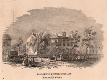
First wall map of Essex County. It includes a plan of Newark. (Much of the lower half of the map will become Union County in 1857.) Fourteen township names in bold capitals hover over their non-demarcated regions: Belleville, Bloomfield, Caldwell, Clinton, Elizabeth, Livingston, New Providence, Newark, Orange, Plainfield, Rahway, Springfield, Union, and Westfield. Engravings of the Bloomfield Female Academy, the Mount Prospect Institute (West Bloomfield), and the county courthouse (Newark) add decorative appeal at the map's bottom. The Bloomfield engravings emphasize the township's early educational efforts: it was one of the first (1849) communities in the state to pass a free-school town law, authorizing the collection of taxes for school purposes.
The map is dense with the names of early landowners. Hachures indicate hilly regions; swamps and wetlands are shaded with marsh grass symbols. Two mountain ranges, named First and Second (today's Watchungs), run vertically in parallel, left of center, down the map.
Three railroads are already prominent in the county, reflecting the rapid development of this form of transportation in the state: Morris and Essex Railroad, New Jersey Railroad, and Central Railroad. Connecting the Delaware River at Phillipsburg to the Hudson River at Jersey City, the Morris Canal enters the county at the top of the map in Bloomfield Township, descends through Belleville Township, and exits through Newark. Completed to Jersey City in 1836, the canal carried anthracite coal from Pennsylvania to New Jersey and New York furnaces until the railroads gradually took over that role. The area marked "Newark Meadows" has largely been filled in and developed. Long gone is the pastoral peace of the area made famous in the paintings and etchings of Hudson River School artist Thomas Moran and his wife, Mary Nimmo Moran, who were Newark residents.
1847: City Wall Map
![E. H. Van Winkle. "Topographical Map of the City of Newark Essex County, N.J. Drawn from Surveys Made by Order of the Common Council" (New York: H. R. Robinson's Lith., 1847) [Historic Maps Collection]. "With Additions by E. C. Smith, City Surveyor." Wall map, with added outline color, 86.5 × 96.5 cm. Scale: 600 feet to 1 inch. One of two known institutional copies.](https://libimages.princeton.edu/loris2/exhibits%2Fnj-historic-maps%2Fessex%2F1847-newark-wall-map.jp2/full/!350,350/0/default.jpg)
First wall map of the city of Newark. The outlines of the four wards of the city—South, West, North, East (clockwise from the left) —are colored orange, yellow, pink, and blue. A very undeveloped East Newark resides across the Passaic River, surrounded with tide-protecting embankment. An inset map locates the city within a larger region that contains New York City, New York and Newark Bays, and neighboring towns and villages. Three tables are prominent, providing statistical data, historical information, and a key to the symbols used. In 1845, for example, there were 25,433 people living in the city in 3,812 dwellings. Within the city limits, there were 504,000 acres of upland and 408,000 acres of marsh. The College of New Jersey (now called Princeton University) was established in the city in 1746, but removed to Princeton in 1754. Roads lawfully opened and built upon are indicated with dark lines; unofficial ones are shown in broken lines.
Because of the presence of so much surrounding marshland, elevations above high tide levels ("El. 32 ft.") are noted on many areas and streets. Figures along and between the streets indicate intervening distances. Forty-three structures, primarily churches, hotels, and public offices, are keyed by capital or lowercase letters. The Morris Canal dissects the map from top to bottom. "The Neck" area at the bottom center, named because of the bend in the Passaic River, is now the working-class neighborhood known as Ironbound. In the later nineteenth and early twentieth centuries, it was filled with industrial plants.
1834: Newark, p-t, and seat of justice, Newark t-ship, Essex co., on the right bank of the Passaic river, between 4 and 5 miles by the course of the stream from Newark bay, 9 miles a little N. and W. from New York, 215 N.E. from W.C., and 49 from Trenton; stands upon a plain of fertile loam, resting on old red sandstone, bounded westward by rising ground which was probably the primitive bank of the river. . . . This is, perhaps, the most flourishing town of the state. . . . There are 1712 dwellings, of which 1518 are wooden, and 194 stone and brick. 109 dwellings were built in 1832, and as many in 1833; many of them large and elegant. The town is remarkable for its manufactures, with which it supplies the market throughout the United States; and in which the great proportion of the inhabitants are engaged. The principal of these are saddler and harness, carriages, shoes, and hats. . . . The prosperity of this enterprising and industrious town, is deservedly great; and being founded on the indispensable manufactures of the country, will necessarily progress with the general population, and with such increased momentum as the highly stimulated spirit of its inhabitants will not fail to give it [Gordon, pp. 189, 194].
1873: City Atlas
![Griffith Morgan Hopkins, Jr. _Combined Atlas of the State of New Jersey and the City of Newark: From Actual Survey, Official Records & Private Plans_ (Philadelphia: G. M. Hopkins & Co., 1873) [Historic Maps Collection]. 113 pp., including maps.](https://libimages.princeton.edu/loris2/exhibits%2Fnj-historic-maps%2Fessex%2F1873-newark-city-atlas-title-page.jp2/full/!320,320/0/default.jpg)
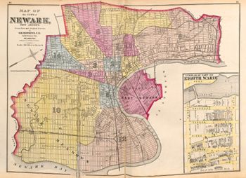
First atlas of the city of Newark. The volume contains a map of New Jersey, maps of all twenty-one counties, and a general map of Newark that identifies the territories of its fifteen wards. Individual maps of the wards and the north and south parts of East Newark follow. The atlas concludes with a six-page "Special Classified Business Directory of the City of Newark, New Jersey," an alphabetical listing of local businesses and services, where subscribers are named under "Subscribers."
Pink, blue, yellow, and pale orange colors identify the city's fifteen wards and East Newark. Much of the Tenth and Twelfth Wards are part of the "Newark Meadows" that are still undeveloped. "The Newark and New York Ship Canal" was envisaged as a navigable ferry connection between New York and the center of Newark but was never realized. Note that the Morris Canal winding through the city ends at the Passaic River. All of that channel was gradually filled in; part of the bed became the route of the Newark City Subway in the 1930s, which runs under a section of today's Raymond Boulevard.
◊ ◊ ◊
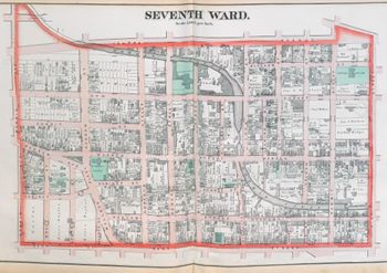
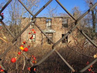
The public schools, churches, jail, and orphanage are in green. Built in 1837, with subsequent additions, the jail (top center) is the oldest public building in Essex County. It was the county's main jail until 1970 when a newer facility opened. A fire caused severe damage in 2001, and the area is currently being considered for development.
The orphan asylum (top right) was founded in 1847; it merged with Protestant Foster Home Society in 1948. Today, the area is part of the New Jersey Institute of Technology.
Back to Top